


J5 ANNABELLE montmel azergues sgmo 35k 170519

ophness
Gebruiker

Lengte
35 km

Max. hoogte
445 m

Positief hoogteverschil
697 m
Km-Effort
45 km

Min. hoogte
187 m

Negatief hoogteverschil
854 m
Boucle
Neen
Datum van aanmaak :
2018-04-17 18:06:42.772
Laatste wijziging :
2018-04-17 18:06:42.772
6h40
Moeilijkheid : Onbekend

Gratisgps-wandelapplicatie
 SityTrail
IGN / Geografische instituten
SityTrail Plus
De wereld gaat voor u open
Over ons
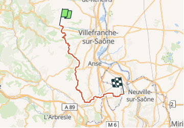
Tocht Paard van 35 km beschikbaar op Auvergne-Rhône-Alpes, Rhône, Denicé. Deze tocht wordt voorgesteld door ophness.
Plaatsbepaling
Land:
France
Regio :
Auvergne-Rhône-Alpes
Departement/Provincie :
Rhône
Gemeente :
Denicé
Locatie:
Unknown
Vertrek:(Dec)
Vertrek:(UTM)
625705 ; 5096165 (31T) N.
Opmerkingen