


blaimont

andre.rochet.ar
Gebruiker
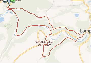

Lengte
6,4 km

Max. hoogte
254 m

Positief hoogteverschil
120 m
Km-Effort
8 km

Min. hoogte
191 m

Negatief hoogteverschil
117 m
Boucle
Ja
Datum van aanmaak :
2018-04-17 20:07:22.966
Laatste wijziging :
2018-04-17 20:07:22.966
1h58
Moeilijkheid : Medium

Gratisgps-wandelapplicatie
 SityTrail
IGN / Geografische instituten
SityTrail Plus
De wereld gaat voor u open
Over ons
Tocht Noords wandelen van 6,4 km beschikbaar op Wallonië, Henegouwen, Chimay. Deze tocht wordt voorgesteld door andre.rochet.ar.
Beschrijving
essai
POI's


Plaatsbepaling
Land:
Belgium
Regio :
Wallonië
Departement/Provincie :
Henegouwen
Gemeente :
Chimay
Locatie:
Virelles
Vertrek:(Dec)
Vertrek:(UTM)
596754 ; 5547261 (31U) N.
Opmerkingen