Tocht Stappen La Petite-Pierre - Chemin vers Graufthal - Photo

Chemin vers Graufthal

 cathel11
cathel11

Gebruiker

© OpenStreetMap contributors
Lengte
Lengte
16,6 km
Max. hoogte
Max. hoogte
383 m
Positief hoogteverschil
601 m
Km-Effort
Km-Effort  
25 km
Min. hoogte
Min. hoogte
200 m
Negatief hoogteverschil
599 m
Boucle
Boucle
Ja
Datum van aanmaak :
2019-03-03 11:37:43.013
Laatste wijziging :
2019-03-03 11:37:43.053

(0 Bericht)

Stappen
Stappen
5h13
Moeilijkheid : Moeilijk

Scan deze QR-code om de tocht te openen in de SityTrail-applicatie

Gratisgps-wandelapplicatie

Logo SityTrail SityTrail

IGN / Geografische instituten

SityTrail uit de App Store downloaden SityTrail uit Google Play downloaden

Logo SityTrail SityTrail Plus

De wereld gaat voor u open

SityTrail uit de App Store downloaden SityTrail uit Google Play downloaden SityTrail op Huawei AppGallery downloaden

Over ons

Tocht Stappen van 16,6 km beschikbaar op Grand Est, Bas-Rhin, La Petite-Pierre. Deze tocht wordt voorgesteld door cathel11.

Beschrijving

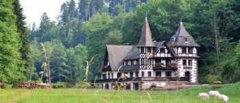
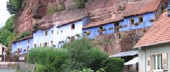
Le départ de cette boucle s'effectue depuis le parking situé devant l'Office du tourisme à La Petite Pierre et nous mènera jusqu'à Graufthal pour une visite des maisons troglodytes par le GR53. Le retour s'effectuera par le rocher des païens et  le rocher blanc

Hoogteprofiel

Foto's

POI's

POI La Petite-Pierre - Parking office du tourisme - Photo
cathel11
LA PETITE-PIERRE 
POI La Petite-Pierre - Rocher du corbeau - Photo
cathel11
LA PETITE-PIERRE 
POI Eschbourg - Moulin de la Petite Pierre - Photo
cathel11
POI La Petite-Pierre - Etang de Dimsthal - Photo
cathel11
LA PETITE-PIERRE 
POI La Petite-Pierre - Rocher blanc - Photo
cathel11
LA PETITE-PIERRE 

Plaatsbepaling

Land:
France
Regio :
Grand Est
Departement/Provincie :
Bas-Rhin
Gemeente :
La Petite-Pierre
Locatie:
Unknown
Vertrek:(Dec)
Vertrek:(UTM)
376745 ; 5412914 (32U) N.


Sluiten
Mijn abonnementen