


2018-03-30 WE CVA Fleckenstein

holtzv
Gebruiker GUIDE
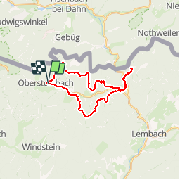

Lengte
25 km

Max. hoogte
415 m

Positief hoogteverschil
710 m
Km-Effort
34 km

Min. hoogte
198 m

Negatief hoogteverschil
710 m
Boucle
Ja
Datum van aanmaak :
2018-04-17 23:27:30.319
Laatste wijziging :
2018-04-17 23:27:30.319
4h12
Moeilijkheid : Medium

Gratisgps-wandelapplicatie
 SityTrail
IGN / Geografische instituten
SityTrail Plus
De wereld gaat voor u open
Over ons
Tocht Paard van 25 km beschikbaar op Grand Est, Bas-Rhin, Obersteinbach. Deze tocht wordt voorgesteld door holtzv.
Plaatsbepaling
Land:
France
Regio :
Grand Est
Departement/Provincie :
Bas-Rhin
Gemeente :
Obersteinbach
Locatie:
Unknown
Vertrek:(Dec)
Vertrek:(UTM)
404364 ; 5432306 (32U) N.
Opmerkingen