


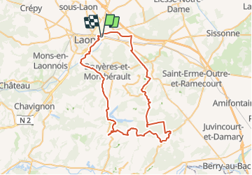
2018-05-04 Laon Jour 2

Lucquiaud
Gebruiker

Lengte
61 km

Max. hoogte
204 m

Positief hoogteverschil
970 m
Km-Effort
74 km

Min. hoogte
61 m

Negatief hoogteverschil
971 m
Boucle
Ja
Datum van aanmaak :
2018-09-15 15:02:51.727
Laatste wijziging :
2018-09-15 15:02:51.738
4h44
Moeilijkheid : Medium

Gratisgps-wandelapplicatie
 SityTrail
IGN / Geografische instituten
SityTrail Plus
De wereld gaat voor u open
Over ons
Tocht Mountainbike van 61 km beschikbaar op Hauts-de-France, Aisne, Laon. Deze tocht wordt voorgesteld door Lucquiaud.
Plaatsbepaling
Land:
France
Regio :
Hauts-de-France
Departement/Provincie :
Aisne
Gemeente :
Laon
Locatie:
Unknown
Vertrek:(Dec)
Vertrek:(UTM)
547422 ; 5490807 (31U) N.
Opmerkingen