Tocht Stappen Préfailles - Circuit Pointe de Saint-Gildas - PREFAILLES - Photo

Circuit Pointe de Saint-Gildas - PREFAILLES

 smu44
smu44

Gebruiker

© OpenStreetMap contributors
Lengte
Lengte
7,3 km
Max. hoogte
Max. hoogte
28 m
Positief hoogteverschil
53 m
Km-Effort
Km-Effort  
8 km
Min. hoogte
Min. hoogte
0 m
Negatief hoogteverschil
51 m
Boucle
Boucle
Ja
Datum van aanmaak :
2018-06-26 13:14:09.063
Laatste wijziging :
2018-06-26 13:14:09.063

(0 Bericht)

Stappen
Stappen
1h49
Moeilijkheid : Gemakkelijk

Scan deze QR-code om de tocht te openen in de SityTrail-applicatie

Gratisgps-wandelapplicatie

Logo SityTrail SityTrail

IGN / Geografische instituten

SityTrail uit de App Store downloaden SityTrail uit Google Play downloaden

Logo SityTrail SityTrail Plus

De wereld gaat voor u open

SityTrail uit de App Store downloaden SityTrail uit Google Play downloaden SityTrail op Huawei AppGallery downloaden

Over ons

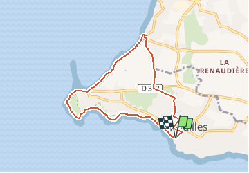
Tocht Stappen van 7,3 km beschikbaar op Pays de la Loire, Loire-Atlantique, Préfailles. Deze tocht wordt voorgesteld door smu44.

Beschrijving

Départ Grande Plage ou Pointe St-Gildas.
Le sentier borde le littoral sur le sommet de la falaises côtières jusqu'à la Grande Plage.
On peut y découvrir de magnifiques chalets de bord de mer, datant pour certains de la fin du XIXe siècle, puis le plateau de la Chapelle, propriété commune et indivise des anciens Préfaillais.
Coupant ensuite au travers du bourg par de petites rues, l'itinéraire rejoint à nouveau le bord de mer à la Prée pour revenir vers le port.

Hoogteprofiel

Plaatsbepaling

Land:
France
Regio :
Pays de la Loire
Departement/Provincie :
Loire-Atlantique
Gemeente :
Préfailles
Locatie:
Unknown
Vertrek:(Dec)
Vertrek:(UTM)
559109 ; 5219666 (30T) N.


Sluiten
Mijn abonnementen