Tocht Mountainbike Illfurth - Allemagne  - Photo
 flip686868
flip686868

Gebruiker

© OpenStreetMap contributors
Lengte
Lengte
146 km
Max. hoogte
Max. hoogte
390 m
Positief hoogteverschil
1317 m
Km-Effort
Km-Effort  
164 km
Min. hoogte
Min. hoogte
210 m
Negatief hoogteverschil
1302 m
Boucle
Boucle
Neen
Datum van aanmaak :
2018-06-26 13:24:41.307
Laatste wijziging :
2018-06-26 13:24:41.307

(0 Bericht)

Mountainbike
Mountainbike
9h27
Moeilijkheid : Onbekend

Scan deze QR-code om de tocht te openen in de SityTrail-applicatie

Gratisgps-wandelapplicatie

Logo SityTrail SityTrail

IGN / Geografische instituten

SityTrail uit de App Store downloaden SityTrail uit Google Play downloaden

Logo SityTrail SityTrail World

De wereld gaat voor u open

SityTrail uit de App Store downloaden SityTrail uit Google Play downloaden SityTrail op Huawei AppGallery downloaden

Over ons

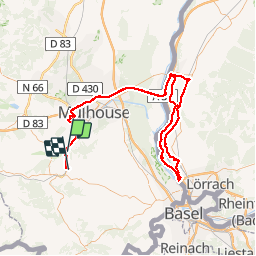
Tocht Mountainbike van 146 km beschikbaar op Grand Est, Haut-Rhin, Illfurth. Deze tocht wordt voorgesteld door flip686868.

Hoogteprofiel

Plaatsbepaling

Land:
France
Regio :
Grand Est
Departement/Provincie :
Haut-Rhin
Gemeente :
Illfurth
Locatie:
Unknown
Vertrek:(Dec)
Vertrek:(UTM)
369915 ; 5281375 (32T) N.

Wandeltochten in de omgeving

Tocht Stappen Illfurth - Illfurth Luemschwillrr Obermorschwiller - Photo
Stappen
selevrich

Stappen

Gemakkelijk
Illfurth, Grand Est, Haut-Rhin, France
28 km | 34 km-effort
3h 28min
Neen
Tocht Elektrische fiets Zillisheim - Montreux-Vieux - Photo
Elektrische fiets
MIFE68

Elektrische fiets

Gemakkelijk
Zillisheim, Grand Est, Haut-Rhin, France
69 km | 75 km-effort
4h 0min
Ja
Tocht Stappen Walheim - Walheim-Illfuhrt (1-3-2018) - Photo
Stappen
Richard68500

Stappen

Gemakkelijk
Walheim, Grand Est, Haut-Rhin, France
13,6 km | 18,2 km-effort
3h 32min
Ja
Tocht Lopen Walheim - noel - Photo
Lopen
flip6868

Lopen

Gemakkelijk
Walheim, Grand Est, Haut-Rhin, France
5,3 km | 6,8 km-effort
55min
Ja
Tocht Lopen Walheim - noel - Photo
Lopen
flip6868

Lopen

Gemakkelijk
Walheim, Grand Est, Haut-Rhin, France
5,3 km | 6,8 km-effort
55min
Ja
Tocht Stappen Zillisheim - Zillisheim  - Photo
Stappen
jeankrust

Stappen

Gemakkelijk
Zillisheim, Grand Est, Haut-Rhin, France
4,7 km | 6,3 km-effort
1h 10min
Ja
Tocht Mountainbike Walheim - 2010-10-31 - 10h56m09 - Photo
Mountainbike
sergeh68

Mountainbike

Heel gemakkelijk
Walheim, Grand Est, Haut-Rhin, France
34 km | 42 km-effort
Onbekend
Ja
Tocht Stappen Frœningen - Étang de Galfingue  - Photo
Stappen
ROPPJP

Stappen

Medium
Frœningen, Grand Est, Haut-Rhin, France
4,9 km | 6 km-effort
1h 18min
Ja
Tocht Stappen Obermorschwiller - 2022 08 15 - Photo
Stappen
jmbilger

Stappen

Gemakkelijk
Obermorschwiller, Grand Est, Haut-Rhin, France
4,4 km | 5,8 km-effort
1h 12min
Neen


Sluiten
Mijn abonnementen