


Arboras

ARVIEU
Gebruiker
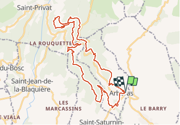

Lengte
23 km

Max. hoogte
677 m

Positief hoogteverschil
713 m
Km-Effort
33 km

Min. hoogte
160 m

Negatief hoogteverschil
718 m
Boucle
Ja
Datum van aanmaak :
2018-06-26 14:38:47.802
Laatste wijziging :
2018-06-26 14:38:47.802
6h00
Moeilijkheid : Medium

Gratisgps-wandelapplicatie
 SityTrail
IGN / Geografische instituten
SityTrail Plus
De wereld gaat voor u open
Over ons
Tocht Stappen van 23 km beschikbaar op Occitanië, Hérault, Arboras. Deze tocht wordt voorgesteld door ARVIEU.
Beschrijving
Le dénivelé est pratiquement absorbé le matin (467 m). Le sol ne présente aucune difficulté, peu de pierres. La marche est rapide.
Plaatsbepaling
Land:
France
Regio :
Occitanië
Departement/Provincie :
Hérault
Gemeente :
Arboras
Locatie:
Unknown
Vertrek:(Dec)
Vertrek:(UTM)
539369 ; 4839919 (31T) N.
Opmerkingen
Pas de difficultés majeures si ce n'est la distance