


mesnil amelot

topolino
Gebruiker
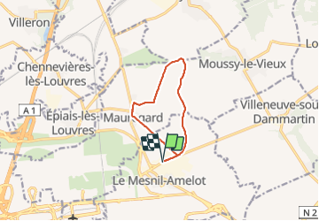

Lengte
8,2 km

Max. hoogte
125 m

Positief hoogteverschil
51 m
Km-Effort
8,9 km

Min. hoogte
98 m

Negatief hoogteverschil
50 m
Boucle
Ja
Datum van aanmaak :
2018-06-26 14:44:15.833
Laatste wijziging :
2018-06-26 14:44:15.833
58m
Moeilijkheid : Heel gemakkelijk

Gratisgps-wandelapplicatie
 SityTrail
IGN / Geografische instituten
SityTrail Plus
De wereld gaat voor u open
Over ons
Tocht Fiets van 8,2 km beschikbaar op Île-de-France, Seine-et-Marne, Le Mesnil-Amelot. Deze tocht wordt voorgesteld door topolino.
Plaatsbepaling
Land:
France
Regio :
Île-de-France
Departement/Provincie :
Seine-et-Marne
Gemeente :
Le Mesnil-Amelot
Locatie:
Unknown
Vertrek:(Dec)
Vertrek:(UTM)
470215 ; 5429981 (31U) N.
Opmerkingen