


calvison 45km

mthomas30
Gebruiker
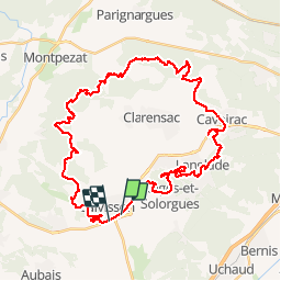

Lengte
47 km

Max. hoogte
200 m

Positief hoogteverschil
780 m
Km-Effort
57 km

Min. hoogte
36 m

Negatief hoogteverschil
773 m
Boucle
Neen
Datum van aanmaak :
2018-06-26 14:59:19.067
Laatste wijziging :
2018-06-26 14:59:19.067
3h46
Moeilijkheid : Medium

Gratisgps-wandelapplicatie
 SityTrail
IGN / Geografische instituten
SityTrail Plus
De wereld gaat voor u open
Over ons
Tocht Mountainbike van 47 km beschikbaar op Occitanië, Gard, Calvisson. Deze tocht wordt voorgesteld door mthomas30.
Plaatsbepaling
Land:
France
Regio :
Occitanië
Departement/Provincie :
Gard
Gemeente :
Calvisson
Locatie:
Unknown
Vertrek:(Dec)
Vertrek:(UTM)
596534 ; 4848370 (31T) N.
Opmerkingen