


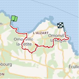
Port Racine le Port du Hâble

Laurent53
Gebruiker

Lengte
10,1 km

Max. hoogte
98 m

Positief hoogteverschil
222 m
Km-Effort
13,1 km

Min. hoogte
0 m

Negatief hoogteverschil
235 m
Boucle
Neen
Datum van aanmaak :
2018-06-26 16:24:08.19
Laatste wijziging :
2018-07-20 09:32:01.671
--
Moeilijkheid : Gemakkelijk

Gratisgps-wandelapplicatie
 SityTrail
IGN / Geografische instituten
SityTrail Plus
De wereld gaat voor u open
Over ons
Tocht Te voet van 10,1 km beschikbaar op Normandië, Manche, La Hague. Deze tocht wordt voorgesteld door Laurent53.
Plaatsbepaling
Land:
France
Regio :
Normandië
Departement/Provincie :
Manche
Gemeente :
La Hague
Locatie:
Saint-Germain-des-Vaux
Vertrek:(Dec)
Vertrek:(UTM)
579474 ; 5507177 (30U) N.
Opmerkingen