Tour Mountainbike Lachapelle-aux-Pots - ACTIVE LOG 003 - Photo
 sebcar
sebcar

Benutzer

© OpenStreetMap contributors
Länge
Länge
19,1 km
Maximale Höhe
Maximale Höhe
237 m
Positive Höhendifferenz
374 m
Km-Effort
Km-Effort  
24 km
Min. Höhe
Min. Höhe
84 m
Negative Höhendifferenz
374 m
Boucle
Boucle
Ja
Erstellungsdatum :
2019-08-23 18:13:09.798
Letzte Änderung :
2019-08-24 12:49:18.958

(1 Nachricht)

Mountainbike
Mountainbike
1h39
Schwierigkeit : Medium

Scannen Sie diesen QR-Code, um die Tour in der SityTrail-Anwendung zu öffnen

Kostenlosegpshiking-Anwendung

Logo SityTrail SityTrail

IGN / Geografische Institute

SityTrail aus dem App Store herunterladen SityTrail von Google Play herunterladen

Logo SityTrail SityTrail World

Die Welt öffnet sich für Sie

SityTrail aus dem App Store herunterladen SityTrail von Google Play herunterladen SityTrail auf Huawei AppGallery herunterladen

Über SityTrail

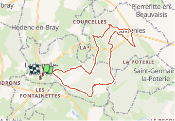
Tour Mountainbike von 19,1 km verfügbar auf Nordfrankreich, Oise, Lachapelle-aux-Pots. Diese Tour wird von sebcar vorgeschlagen.

Beschreibung

Belle façon de découvrir les caractéristiques paysagères et géologiques du flanc est du pays de Bray.
Attention à Lhuyère le chemin à disparu suite à un "remembrement personnalisé" du cultivateur.

Höhenprofil

Ort

Land:
France
Region :
Nordfrankreich
Abteilung/Provinz :
Oise
Kommune :
Lachapelle-aux-Pots
Standort:
Unknown
Gehen Sie:(Dec)
Gehen Sie:(UTM)
420392 ; 5477224 (31U) N.

Kommentare

Bitte melden Sie sich an, um einen Kommentar oder eine Bewertung zu hinterlassen


Touren in der Umgebung

Tour Mountainbike Pierrefitte-en-Beauvaisis - Grand tour - Photo
Mountainbike
jjeletufe

Mountainbike

(1)
Pierrefitte-en-Beauvaisis, Nordfrankreich, Oise, France
30 km | 35 km-effort
1h 44min
Ja
Tour Wandern Senantes - Senantes - Photo
Wandern
jpblimond

Wandern

Medium
Senantes, Nordfrankreich, Oise, France
18,7 km | 23 km-effort
4h 47min
Ja
Tour Wandern Lalandelle - Forêt domaniale de Thelle à partir de Lalandelle - Photo
Wandern
Marie-Claire-mcp

Wandern

Schwierig
Lalandelle, Nordfrankreich, Oise, France
11 km | 13,1 km-effort
2h 59min
Ja
Tour Wandern Lachapelle-aux-Pots - Lachapelle-aux-pots - Héricourt - La Frénoye - Armentières - Photo
Wandern
Marie-Claire-mcp

Wandern

Schwierig
Lachapelle-aux-Pots, Nordfrankreich, Oise, France
10,7 km | 13,7 km-effort
3h 6min
Ja
Tour Wandern Lachapelle-aux-Pots - Lachapelle aux pots - Armentières 11 km - Photo
Wandern
Marie-Claire-mcp

Wandern

Schwierig
Lachapelle-aux-Pots, Nordfrankreich, Oise, France
10,6 km | 13,5 km-effort
3h 4min
Ja
Tour Wandern Lachapelle-aux-Pots - Lachapelle aux Pots - Rando santé 1 - Photo
Wandern
marcel.F

Wandern

Medium
Lachapelle-aux-Pots, Nordfrankreich, Oise, France
5,6 km | 6,4 km-effort
1h 24min
Ja
Tour Wandern Lachapelle-aux-Pots - Lachapelle-aux-Pots - autour de la Crapaudière vers 2 - Photo
Wandern
marcel.F

Wandern

Einfach
Lachapelle-aux-Pots, Nordfrankreich, Oise, France
9,9 km | 11,5 km-effort
2h 32min
Ja
Tour Wandern Lachapelle-aux-Pots - Lachapelle-aux-Pots - autour de la Crapaudière - Photo
Wandern
marcel.F

Wandern

Einfach
Lachapelle-aux-Pots, Nordfrankreich, Oise, France
9,4 km | 10,9 km-effort
2h 25min
Ja
Tour Wandern Lachapelle-aux-Pots - Lachapelle aux pots Gare - Photo
Wandern
Marie-Claire-mcp

Wandern

Medium
Lachapelle-aux-Pots, Nordfrankreich, Oise, France
10,6 km | 12,4 km-effort
2h 37min
Ja


Schließen
Meine Abonnements