Tour Wandern Lachapelle-aux-Pots - Lachapelle aux Pots - Rando santé 1 - Photo

Lachapelle aux Pots - Rando santé 1

 marcel.F
marcel.F

Benutzer

© OpenStreetMap contributors
Länge
Länge
5,6 km
Maximale Höhe
Maximale Höhe
115 m
Positive Höhendifferenz
61 m
Km-Effort
Km-Effort  
6,4 km
Min. Höhe
Min. Höhe
86 m
Negative Höhendifferenz
61 m
Boucle
Boucle
Ja
Erstellungsdatum :
2020-02-13 14:44:04.471
Letzte Änderung :
2020-02-13 14:45:10.58

(0 Nachricht)

Wandern
Wandern
1h24
Schwierigkeit : Medium

Scannen Sie diesen QR-Code, um die Tour in der SityTrail-Anwendung zu öffnen

Kostenlosegpshiking-Anwendung

Logo SityTrail SityTrail

IGN / Geografische Institute

SityTrail aus dem App Store herunterladen SityTrail von Google Play herunterladen

Logo SityTrail SityTrail World

Die Welt öffnet sich für Sie

SityTrail aus dem App Store herunterladen SityTrail von Google Play herunterladen SityTrail auf Huawei AppGallery herunterladen

Über SityTrail

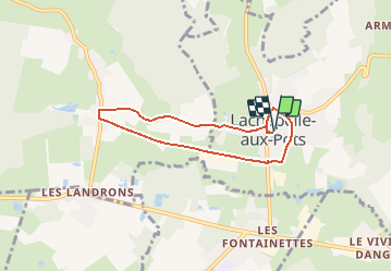
Tour Wandern von 5,6 km verfügbar auf Nordfrankreich, Oise, Lachapelle-aux-Pots. Diese Tour wird von marcel.F vorgeschlagen.

Beschreibung

départ parking de la mairie

Höhenprofil

Ort

Land:
France
Region :
Nordfrankreich
Abteilung/Provinz :
Oise
Kommune :
Lachapelle-aux-Pots
Standort:
Unknown
Gehen Sie:(UTM)
420394 ; 5477769 (31U) N.

Touren in der Umgebung

Tour Mountainbike Lachapelle-aux-Pots - ACTIVE LOG 003 - Photo
Mountainbike
sebcar

Mountainbike

Medium
(1)
Lachapelle-aux-Pots, Nordfrankreich, Oise, France
19,1 km | 24 km-effort
1h 39min
Ja
Tour Mountainbike Pierrefitte-en-Beauvaisis - Grand tour - Photo
Mountainbike
jjeletufe

Mountainbike

(1)
Pierrefitte-en-Beauvaisis, Nordfrankreich, Oise, France
30 km | 35 km-effort
1h 44min
Ja
Tour Wandern Senantes - Senantes - Photo
Wandern
jpblimond

Wandern

Medium
Senantes, Nordfrankreich, Oise, France
18,7 km | 23 km-effort
4h 47min
Ja
Tour Wandern Lachapelle-aux-Pots - Lachapelle-aux-pots - Héricourt - La Frénoye - Armentières - Photo
Wandern
Marie-Claire-mcp

Wandern

Schwierig
Lachapelle-aux-Pots, Nordfrankreich, Oise, France
10,7 km | 13,7 km-effort
3h 6min
Ja
Tour Wandern Lachapelle-aux-Pots - Lachapelle aux pots - Armentières 11 km - Photo
Wandern
Marie-Claire-mcp

Wandern

Schwierig
Lachapelle-aux-Pots, Nordfrankreich, Oise, France
10,6 km | 13,5 km-effort
3h 4min
Ja
Tour Wandern Lachapelle-aux-Pots - Lachapelle-aux-Pots - autour de la Crapaudière vers 2 - Photo
Wandern
marcel.F

Wandern

Einfach
Lachapelle-aux-Pots, Nordfrankreich, Oise, France
9,9 km | 11,5 km-effort
2h 32min
Ja
Tour Wandern Lachapelle-aux-Pots - Lachapelle-aux-Pots - autour de la Crapaudière - Photo
Wandern
marcel.F

Wandern

Einfach
Lachapelle-aux-Pots, Nordfrankreich, Oise, France
9,4 km | 10,9 km-effort
2h 25min
Ja
Tour Wandern Lachapelle-aux-Pots - Lachapelle aux pots Gare - Photo
Wandern
Marie-Claire-mcp

Wandern

Medium
Lachapelle-aux-Pots, Nordfrankreich, Oise, France
10,6 km | 12,4 km-effort
2h 37min
Ja
Tour Wandern Lachapelle-aux-Pots - Lachapelle aux pots - Photo
Wandern
Marie-Claire-mcp

Wandern

Einfach
Lachapelle-aux-Pots, Nordfrankreich, Oise, France
10,2 km | 12 km-effort
2h 37min
Ja


Schließen
Meine Abonnements