Tour Wandern Lachapelle-aux-Pots - Lachapelle aux pots Gare - Photo

Lachapelle aux pots Gare

© OpenStreetMap contributors
Länge
Länge
10,6 km
Maximale Höhe
Maximale Höhe
152 m
Positive Höhendifferenz
137 m
Km-Effort
Km-Effort  
12,4 km
Min. Höhe
Min. Höhe
84 m
Negative Höhendifferenz
137 m
Boucle
Boucle
Ja
Erstellungsdatum :
2018-04-17 13:20:15.293
Letzte Änderung :
2018-04-17 13:20:15.293

(0 Nachricht)

Wandern
Wandern
2h37
Schwierigkeit : Medium

Scannen Sie diesen QR-Code, um die Tour in der SityTrail-Anwendung zu öffnen

Kostenlosegpshiking-Anwendung

Logo SityTrail SityTrail

IGN / Geografische Institute

SityTrail aus dem App Store herunterladen SityTrail von Google Play herunterladen

Logo SityTrail SityTrail World

Die Welt öffnet sich für Sie

SityTrail aus dem App Store herunterladen SityTrail von Google Play herunterladen SityTrail auf Huawei AppGallery herunterladen

Über SityTrail

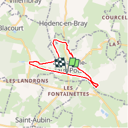
Tour Wandern von 10,6 km verfügbar auf Nordfrankreich, Oise, Lachapelle-aux-Pots. Diese Tour wird von Marie-Claire-mcp vorgeschlagen.

Beschreibung

Lachapelle aux pots Gare prendre la voie verte jusqu'à Vivier Danger, puis prendre la route à gauche et au virage le chemin à gauche (rue de la Ferme) puis rue de Gerberoy, entrer dans le bois et continuer jusqu'au Rutoire. Traverser la route qui mène à Hodent et grimper le chemin jusqu'en haut et tourner à gauche puis avant d'arriver à la crapaudière, tourner à droite direction Blacourt, au bout prendre la route à droite puis après La Boissière prendre le chemin noir à gauche jusqu'aux maisons et tourner à gauche puis à gauche la voie verte jusqu'à la gare de Lachapelle aux pots.

Höhenprofil

Ort

Land:
France
Region :
Nordfrankreich
Abteilung/Provinz :
Oise
Kommune :
Lachapelle-aux-Pots
Standort:
Unknown
Gehen Sie:(Dec)
Gehen Sie:(UTM)
420270 ; 5477423 (31U) N.

Touren in der Umgebung

Tour Mountainbike Lachapelle-aux-Pots - ACTIVE LOG 003 - Photo
Mountainbike
sebcar

Mountainbike

Medium
(1)
Lachapelle-aux-Pots, Nordfrankreich, Oise, France
19,1 km | 24 km-effort
1h 39min
Ja
Tour Mountainbike Pierrefitte-en-Beauvaisis - Grand tour - Photo
Mountainbike
jjeletufe

Mountainbike

(1)
Pierrefitte-en-Beauvaisis, Nordfrankreich, Oise, France
30 km | 35 km-effort
1h 44min
Ja
Tour Wandern Senantes - Senantes - Photo
Wandern
jpblimond

Wandern

Medium
Senantes, Nordfrankreich, Oise, France
18,7 km | 23 km-effort
4h 47min
Ja
Tour Wandern Lalandelle - Forêt domaniale de Thelle à partir de Lalandelle - Photo
Wandern
Marie-Claire-mcp

Wandern

Schwierig
Lalandelle, Nordfrankreich, Oise, France
11 km | 13,1 km-effort
2h 59min
Ja
Tour Wandern Lachapelle-aux-Pots - Lachapelle-aux-pots - Héricourt - La Frénoye - Armentières - Photo
Wandern
Marie-Claire-mcp

Wandern

Schwierig
Lachapelle-aux-Pots, Nordfrankreich, Oise, France
10,7 km | 13,7 km-effort
3h 6min
Ja
Tour Wandern Lachapelle-aux-Pots - Lachapelle aux pots - Armentières 11 km - Photo
Wandern
Marie-Claire-mcp

Wandern

Schwierig
Lachapelle-aux-Pots, Nordfrankreich, Oise, France
10,6 km | 13,5 km-effort
3h 4min
Ja
Tour Wandern Lachapelle-aux-Pots - Lachapelle aux Pots - Rando santé 1 - Photo
Wandern
marcel.F

Wandern

Medium
Lachapelle-aux-Pots, Nordfrankreich, Oise, France
5,6 km | 6,4 km-effort
1h 24min
Ja
Tour Wandern Lachapelle-aux-Pots - Lachapelle-aux-Pots - autour de la Crapaudière vers 2 - Photo
Wandern
marcel.F

Wandern

Einfach
Lachapelle-aux-Pots, Nordfrankreich, Oise, France
9,9 km | 11,5 km-effort
2h 32min
Ja
Tour Wandern Lachapelle-aux-Pots - Lachapelle-aux-Pots - autour de la Crapaudière - Photo
Wandern
marcel.F

Wandern

Einfach
Lachapelle-aux-Pots, Nordfrankreich, Oise, France
9,4 km | 10,9 km-effort
2h 25min
Ja


Schließen
Meine Abonnements