![](/images/other/stat-length.png)
![Tour Wandern Lüttich - Sart Tilman - Landes de Streupas - Photo](https://media.geolcdn.com/t/1900/400/ext.pjpeg?maxdim=2&url=https%3A%2F%2Fmedia.geolcdn.com%2Ff%2F1aa98ec0-d287-4dcb-81ef-7318b44bdc91.jpg)
Sart Tilman - Landes de Streupas
DeP
J'irai où tu iras
![Länge](/images/other/stat-length.png)
Länge
9,7 km
![Maximale Höhe](https://static1.geolcdn.com/siteimages/upload/files/1508320355ic_sort_altitude_max_24dp.png)
Maximale Höhe
244 m
![Positive Höhendifferenz](https://static1.geolcdn.com/siteimages/upload/files/1508320355ic_sort_den_pos_24dp.png)
Positive Höhendifferenz
255 m
![Km-Effort](/images/other/stat-length.png)
Km-Effort
13 km
![Min. Höhe](https://static1.geolcdn.com/siteimages/upload/files/1508320355ic_sort_altitude_min_24dp.png)
Min. Höhe
69 m
![Negative Höhendifferenz](https://static1.geolcdn.com/siteimages/upload/files/1508320355ic_sort_den_neg_24dp.png)
Negative Höhendifferenz
251 m
![Boucle](https://static1.geolcdn.com/siteimages/upload/files/16400158638029165_repeat_loop_refresh_sync_direction_icon.png)
Boucle
Ja
Erstellungsdatum :
2021-02-28 14:02:40.0
Letzte Änderung :
2021-02-28 16:52:52.642
![Wandern](https://static1.geolcdn.com/sitytour/trail-icons/101.png)
2h18
Schwierigkeit : Schwierig
![Scannen Sie diesen QR-Code, um die Tour in der SityTrail-Anwendung zu öffnen](https://capi.geolives.com/qq0zvz2zws4bq2lad0pu/sitytour/trails/2689636/qr.png?size=200)
Kostenlosegpshiking-Anwendung
Über SityTrail
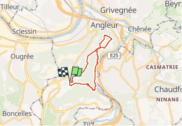
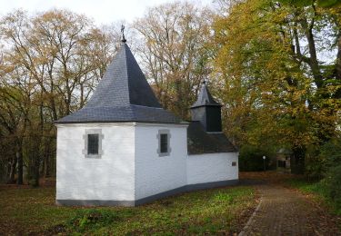
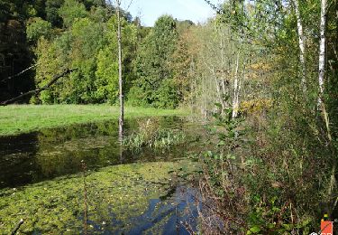
Tour Wandern von 9,7 km verfügbar auf Wallonien, Lüttich, Lüttich. Diese Tour wird von DeP vorgeschlagen.
Beschreibung
Aller super balade et Landes surprenante avec vue incontournable. Retour le long de l’Ourthe par le Ravel nettement moins bucolique et remontée raide .
Ort
Land:
Belgium
Region :
Wallonien
Abteilung/Provinz :
Lüttich
Kommune :
Lüttich
Standort:
Angleur
Gehen Sie:(Dec)
Gehen Sie:(UTM)
682049 ; 5607123 (31U) N.
Kommentare
Touren in der Umgebung
![Tour Wandern Esneux - RB-Lg-20_Tilff - Photo](https://media.geolcdn.com/t/375/260/ext.jpg?maxdim=2&url=https%3A%2F%2Fservices.sitytrail.com%2FGeolivesWS%2FDownloadMedia.ashx%3FTrailID%3D400739%26Media%3D2cb4df8e-af53-4650-9797-54389fe3086f.jpg)
![Wandern Wandern](https://static1.geolcdn.com/sitytour/trail-icons/101.png)
RB-Lg-20_Tilff
Wandern
Sehr schwierig
(6)
Esneux,
Wallonien,
Lüttich,
Belgium
![](/images/other/stat-length.png)
20 km | 28 km-effort
6h 21min
![](https://static1.geolcdn.com/siteimages/upload/files/16400158638029165_repeat_loop_refresh_sync_direction_icon.png)
Ja
![Tour Wandern Neupré - Neupré - les contreforts de la Boucle de l'Ourthe - Photo](https://media.geolcdn.com/t/375/260/ext.jpg?maxdim=2&url=https%3A%2F%2Fservices.sitytrail.com%2FGeolivesWS%2FDownloadMedia.ashx%3FTrailID%3D347434%26Media%3Dfix__20140909180027.jpg)
![Wandern Wandern](https://static1.geolcdn.com/sitytour/trail-icons/101.png)
Neupré - les contreforts de la Boucle de l'Ourthe
Wandern
Medium
(18)
Neupré,
Wallonien,
Lüttich,
Belgium
![](/images/other/stat-length.png)
7,9 km | 10,9 km-effort
2h 21min
![](https://static1.geolcdn.com/siteimages/upload/files/16400158638029165_repeat_loop_refresh_sync_direction_icon.png)
Ja
![Tour Wandern Chaudfontaine - Chaudfontaine, Natura 2000 - Des sites qui valent le détour, Lg7 - Photo](https://media.geolcdn.com/t/375/260/ext.jpg?maxdim=2&url=https%3A%2F%2Fservices.sitytrail.com%2FGeolivesWS%2FDownloadMedia.ashx%3FTrailID%3D188128%26Media%3Df5c5efa3-ad1d-47ec-bc6a-d75c5f96ada1.JPG)
![Wandern Wandern](https://static1.geolcdn.com/sitytour/trail-icons/101.png)
Chaudfontaine, Natura 2000 - Des sites qui valent le détour, Lg7
Wandern
Schwierig
(13)
Chaudfontaine,
Wallonien,
Lüttich,
Belgium
![](/images/other/stat-length.png)
5,3 km | 8,7 km-effort
1h 48min
![](https://static1.geolcdn.com/siteimages/upload/files/16400158638029165_repeat_loop_refresh_sync_direction_icon.png)
Ja
![Tour Wandern Lüttich - Nuit du scoutisme - Liège - Photo](https://media.geolcdn.com/t/375/260/ext.jpg?maxdim=2&url=https%3A%2F%2Fmedia.geolcdn.com%2Ff%2F9ee5fcc5-2ed6-4f9c-9105-1fa3b4422f73.jpg)
![Wandern Wandern](https://static1.geolcdn.com/sitytour/trail-icons/101.png)
Nuit du scoutisme - Liège
Wandern
Einfach
(12)
Lüttich,
Wallonien,
Lüttich,
Belgium
![](/images/other/stat-length.png)
4,2 km | 6 km-effort
1h 19min
![](https://static1.geolcdn.com/siteimages/upload/files/16400158638029165_repeat_loop_refresh_sync_direction_icon.png)
Ja
![Tour Wandern Neupré - Neupré - Sentier Paysage et Géologie - Photo](https://media.geolcdn.com/t/375/260/ext.jpg?maxdim=2&url=https%3A%2F%2Fservices.sitytrail.com%2FGeolivesWS%2FDownloadMedia.ashx%3FTrailID%3D343711%26Media%3Dfix__20140909182657.jpg)
![Wandern Wandern](https://static1.geolcdn.com/sitytour/trail-icons/101.png)
Neupré - Sentier Paysage et Géologie
Wandern
Einfach
(8)
Neupré,
Wallonien,
Lüttich,
Belgium
![](/images/other/stat-length.png)
2,7 km | 3,6 km-effort
50min
![](https://static1.geolcdn.com/siteimages/upload/files/16400158638029165_repeat_loop_refresh_sync_direction_icon.png)
Ja
![Tour Wandern Esneux - 2023-11-10_18h47m33_1728.gpx.xml - Photo](https://media.geolcdn.com/t/375/260/ext.jpg?maxdim=2&url=https%3A%2F%2Fmedia.geolcdn.com%2Ff%2Fc48a71c5-4004-4c2c-808e-9fa33492e14f.jpg)
![Wandern Wandern](https://static1.geolcdn.com/sitytour/trail-icons/101.png)
2023-11-10_18h47m33_1728.gpx.xml
Wandern
Medium
(1)
Esneux,
Wallonien,
Lüttich,
Belgium
![](/images/other/stat-length.png)
9,8 km | 13,5 km-effort
3h 4min
![](https://static1.geolcdn.com/siteimages/upload/files/16400158638029165_repeat_loop_refresh_sync_direction_icon.png)
Ja
![Tour Wandern Lüttich - GG-Lg-10_Angleur - Nessonvaux - Photo](https://media.geolcdn.com/t/375/260/ext.jpg?maxdim=2&url=https%3A%2F%2Fmedia.geolcdn.com%2Ff%2F04d5e1fb-7fbe-4c80-8636-73a8d0ed7b0e.jpg)
![Wandern Wandern](https://static1.geolcdn.com/sitytour/trail-icons/101.png)
GG-Lg-10_Angleur - Nessonvaux
Wandern
Sehr schwierig
(2)
Lüttich,
Wallonien,
Lüttich,
Belgium
![](/images/other/stat-length.png)
22 km | 32 km-effort
6h 27min
![](https://static1.geolcdn.com/siteimages/upload/files/16400158638029165_repeat_loop_refresh_sync_direction_icon.png)
Nein
![Tour Wandern Esneux - RB-Lg-21_Chaudfontaine_via-racc-1 - Photo](https://media.geolcdn.com/t/375/260/ext.jpg?maxdim=2&url=https%3A%2F%2Fservices.sitytrail.com%2FGeolivesWS%2FDownloadMedia.ashx%3FTrailID%3D400755%26Media%3Db4e5d748-2e9a-46aa-887f-e41bafbe80d7.jpg)
![Wandern Wandern](https://static1.geolcdn.com/sitytour/trail-icons/101.png)
RB-Lg-21_Chaudfontaine_via-racc-1
Wandern
Schwierig
(3)
Esneux,
Wallonien,
Lüttich,
Belgium
![](/images/other/stat-length.png)
11 km | 15,7 km-effort
3h 33min
![](https://static1.geolcdn.com/siteimages/upload/files/16400158638029165_repeat_loop_refresh_sync_direction_icon.png)
Ja
![Tour Wandern Esneux - RB-Lg-20_Tilff_via-racc-3 - Photo](https://media.geolcdn.com/t/375/260/ext.jpg?maxdim=2&url=https%3A%2F%2Fservices.sitytrail.com%2FGeolivesWS%2FDownloadMedia.ashx%3FTrailID%3D400745%26Media%3D2cb4df8e-af53-4650-9797-54389fe3086f.jpg)
![Wandern Wandern](https://static1.geolcdn.com/sitytour/trail-icons/101.png)
RB-Lg-20_Tilff_via-racc-3
Wandern
Sehr schwierig
(5)
Esneux,
Wallonien,
Lüttich,
Belgium
![](/images/other/stat-length.png)
16,6 km | 23 km-effort
5h 14min
![](https://static1.geolcdn.com/siteimages/upload/files/16400158638029165_repeat_loop_refresh_sync_direction_icon.png)
Ja