Tour Wandern Mont-Saint-Guibert - #220506 - Mont-Saint-Guibert, rive de l'Orne, l'Espinette*** - Photo

#220506 - Mont-Saint-Guibert, rive de l'Orne, l'Espinette***

© OpenStreetMap contributors
Länge
Länge
7,9 km
Maximale Höhe
Maximale Höhe
135 m
Positive Höhendifferenz
130 m
Km-Effort
Km-Effort  
9,6 km
Min. Höhe
Min. Höhe
77 m
Negative Höhendifferenz
130 m
Boucle
Boucle
Ja
Erstellungsdatum :
2022-05-03 15:07:09.753
Letzte Änderung :
2022-05-03 15:17:55.108

(0 Nachricht)

Wandern
Wandern
2h10
Schwierigkeit : Medium

Scannen Sie diesen QR-Code, um die Tour in der SityTrail-Anwendung zu öffnen

Kostenlosegpshiking-Anwendung

Logo SityTrail SityTrail

IGN / Geografische Institute

SityTrail aus dem App Store herunterladen SityTrail von Google Play herunterladen

Logo SityTrail SityTrail World

Die Welt öffnet sich für Sie

SityTrail aus dem App Store herunterladen SityTrail von Google Play herunterladen SityTrail auf Huawei AppGallery herunterladen

Über SityTrail

Tour Wandern von 7,9 km verfügbar auf Wallonien, Wallonisch-Brabant, Mont-Saint-Guibert. Diese Tour wird von Randos Ouvertes vorgeschlagen.

Beschreibung

Nouveau circuit à tester

Höhenprofil

POIs

POI Mont-Saint-Guibert - Mont-saint-guibert Emplacement vélos f1 - Photo
Randos Ouvertes
MONT-SAINT-GUIBERT 
POI Walhain - Vue nord-ouest dans le Champ de Genister - Photo
Randos Ouvertes
POI Walhain - Vues du champ de Genister vers le Val d'Alvaux - Photo
Randos Ouvertes
POI Walhain - Ruine de la Tour d'Alvau ou Tour des Sarrasins - Photo
Randos Ouvertes
POI Walhain - Vue sur l'Orne - Photo
Randos Ouvertes
POI Mont-Saint-Guibert - Vues de l'Orne depuis la Rue d'Alvau - Photo
Randos Ouvertes
MONT-SAINT-GUIBERT 
POI Mont-Saint-Guibert - Chapelle à l'entrée de la Rue d'Alvau - Photo
Randos Ouvertes
POI Mont-Saint-Guibert - Vues nord et sud dans le chemin qui descend de la Colline de Penuel - Photo
Randos Ouvertes
MONT-SAINT-GUIBERT 
POI Mont-Saint-Guibert - Vue vers la ligne 161 - Photo
Randos Ouvertes
MONT-SAINT-GUIBERT 
POI Mont-Saint-Guibert - Vue ouest dans le Chemin Tollet - Photo
Randos Ouvertes
MONT-SAINT-GUIBERT 
POI Mont-Saint-Guibert - Vue nord-ouest Chemin Tollet - Photo
Randos Ouvertes
MONT-SAINT-GUIBERT 
POI Mont-Saint-Guibert - Vues au sommet de la Rue Al Poudre - Photo
Randos Ouvertes
MONT-SAINT-GUIBERT 
POI Mont-Saint-Guibert - Vue sud-ouest à travers le tunnel sous la ligne 161 - Photo
Randos Ouvertes
POI Chastre - Vues du Moulin Al Poudre - Photo
Randos Ouvertes
POI Chastre - Vue nord sur jardin rue de Bau - Photo
Randos Ouvertes
POI Chastre - Vue sur plan d'eau et rochers de l'ancienne carrière des Molignats - Photo
Randos Ouvertes
POI Walhain - Ferme de la Tour - Photo
Randos Ouvertes
POI Mont-Saint-Guibert - Axis Guibertin - Photo
Randos Ouvertes
MONT-SAINT-GUIBERT 
POI Mont-Saint-Guibert - Église Saint-Guibert de Mont-Saint-Guibert - Photo
Randos Ouvertes
POI Mont-Saint-Guibert - Château de Bierbais - Photo
Randos Ouvertes
MONT-SAINT-GUIBERT 
POI Mont-Saint-Guibert - Donjon de Bierbais - Photo
Randos Ouvertes
MONT-SAINT-GUIBERT 
POI Walhain - Tour d'Alvaux - Photo
Randos Ouvertes
WALHAIN 
POI Mont-Saint-Guibert - Église Sainte-Gertrude de Hévillers - Photo
Randos Ouvertes
POI Mont-Saint-Guibert - Gare de Mont-Saint-Guibert - Photo
Randos Ouvertes
MONT-SAINT-GUIBERT 
POI Mont-Saint-Guibert - Mont-Saint-Guibert - Photo
Randos Ouvertes
MONT-SAINT-GUIBERT 
POI Mont-Saint-Guibert - Séparation Groupe Cyclo & Sport - Photo
Randos Ouvertes
POI Mont-Saint-Guibert - Comme Chez Vous - Photo
Randos Ouvertes
MONT-SAINT-GUIBERT 
POI Mont-Saint-Guibert - Hévillers - Photo
Randos Ouvertes
MONT-SAINT-GUIBERT 
POI Mont-Saint-Guibert - Saint-Guibert - Photo
Randos Ouvertes
MONT-SAINT-GUIBERT 

Ort

Land:
Belgium
Region :
Wallonien
Abteilung/Provinz :
Wallonisch-Brabant
Kommune :
Mont-Saint-Guibert
Standort:
Mont-Saint-Guibert
Gehen Sie:(Dec)
Gehen Sie:(UTM)
613543 ; 5610615 (31U) N.

Touren in der Umgebung

Tour Wandern Ottignies-Louvain-la-Neuve - Nuit du scoutisme - Louvain-la-Neuve - Photo
Wandern
PRO

Wandern

Medium
(16)
Ottignies-Louvain-la-Neuve, Wallonien, Wallonisch-Brabant, Belgium
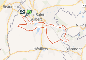
5,7 km | 6,7 km-effort
1h 27min
Ja
Tour Wandern Court-Saint-Étienne - GG2-Bw-22_La-Roche-Blanmont_2021-11-04 - Photo
Wandern
PRO

Wandern

Medium
(2)
Court-Saint-Étienne, Wallonien, Wallonisch-Brabant, Belgium
21 km | 26 km-effort
5h 51min
Nein
Tour Wandern Ottignies-Louvain-la-Neuve - GG-Bw-02_Céroux-Mousty - Villers-la-Ville - Photo
Wandern
PRO

Wandern

Sehr schwierig
(2)
Ottignies-Louvain-la-Neuve, Wallonien, Wallonisch-Brabant, Belgium
20 km | 26 km-effort
5h 37min
Nein
Tour Wandern Mont-Saint-Guibert - Balade à Mont-Saint-Guibert - Photo
Wandern
GUIDE
Desrumaux

Wandern

Sehr leicht
(1)
Mont-Saint-Guibert, Wallonien, Wallonisch-Brabant, Belgium
8,4 km | 10,1 km-effort
2h 12min
Ja
Tour Wandern Ottignies-Louvain-la-Neuve - Balade dans le Bois de Lauzelle - Photo
Wandern
GUIDE
Desrumaux

Wandern

Sehr leicht
(1)
Ottignies-Louvain-la-Neuve, Wallonien, Wallonisch-Brabant, Belgium
6,3 km | 8,1 km-effort
1h 44min
Ja
Tour Wandern Court-Saint-Étienne - RB-BW-08 - À la rencontre de trois vallées - Photo
Wandern
PRO

Wandern

Sehr schwierig
(2)
Court-Saint-Étienne, Wallonien, Wallonisch-Brabant, Belgium
26 km | 32 km-effort
7h 18min
Ja
Tour Wandern Chastre - #240223a - Blanmont, Orne, Alvaux, Nil Pierreux*** - Photo
Wandern
Randos Ouvertes

Wandern

Medium
(1)
Chastre, Wallonien, Wallonisch-Brabant, Belgium
6,6 km | 7,8 km-effort
1h 47min
Ja
Tour Wandern Court-Saint-Étienne - #240304 - La Roche, bois Ste Catherine et du Sartage - Photo
Wandern
Randos Ouvertes

Wandern

Medium
(1)
Court-Saint-Étienne, Wallonien, Wallonisch-Brabant, Belgium
5,8 km | 7,6 km-effort
1h 42min
Ja
Tour Wandern Chaumont-Gistoux - #231016 - Corroy-Le-Grand et le Val d'Ocquière*** (inversé court) - Photo
Wandern
Randos Ouvertes

Wandern

Medium
(2)
Chaumont-Gistoux, Wallonien, Wallonisch-Brabant, Belgium
6,2 km | 7,2 km-effort
1h 38min
Ja


Schließen
Meine Abonnements