Trail Walking Mont-Saint-Guibert - #220506 - Mont-Saint-Guibert, rive de l'Orne, l'Espinette*** - Photo

#220506 - Mont-Saint-Guibert, rive de l'Orne, l'Espinette***

© OpenStreetMap contributors
Length
Length
7.9 km
Max alt
Max alt
135 m
Uphill gradient
Uphill gradient
130 m
Km-Effort
Km-Effort  
9.6 km
Min alt
Min alt
77 m
Downhill gradient
Downhill gradient
130 m
Boucle
Boucle
Yes
Creation date :
2022-05-03 15:07:09.753
Updated on :
2022-05-03 15:17:55.108

(0 Reviews)

Walking
Walking
2h10
Difficulty : Medium

Scan this QR Code to open this trail in the SityTrail application

FREE GPS app for hiking

Logo SityTrail SityTrail

IGN / Geographical institutes

Download SityTrail from the App Store Download SityTrail from Google Play

Logo SityTrail SityTrail World

The world is yours!

Download SityTrail from the App Store Download SityTrail from Google Play Download SityTrail on Huawei AppGallery

About

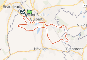
Trail Walking of 7.9 km to be discovered at Wallonia, Walloon Brabant, Mont-Saint-Guibert. This trail is proposed by Randos Ouvertes.

Description

Nouveau circuit à tester

Elevation profile

Points of interest

Point of interest Mont-Saint-Guibert - Mont-saint-guibert Emplacement vélos f1 - Photo
Randos Ouvertes
MONT-SAINT-GUIBERT 
Point of interest Walhain - Vue nord-ouest dans le Champ de Genister - Photo
Randos Ouvertes
Point of interest Walhain - Vues du champ de Genister vers le Val d'Alvaux - Photo
Randos Ouvertes
Point of interest Walhain - Ruine de la Tour d'Alvau ou Tour des Sarrasins - Photo
Randos Ouvertes
Point of interest Walhain - Vue sur l'Orne - Photo
Randos Ouvertes
Point of interest Mont-Saint-Guibert - Vues de l'Orne depuis la Rue d'Alvau - Photo
Randos Ouvertes
MONT-SAINT-GUIBERT 
Point of interest Mont-Saint-Guibert - Chapelle à l'entrée de la Rue d'Alvau - Photo
Randos Ouvertes
Point of interest Mont-Saint-Guibert - Vues nord et sud dans le chemin qui descend de la Colline de Penuel - Photo
Randos Ouvertes
MONT-SAINT-GUIBERT 
Point of interest Mont-Saint-Guibert - Vue vers la ligne 161 - Photo
Randos Ouvertes
MONT-SAINT-GUIBERT 
Point of interest Mont-Saint-Guibert - Vue ouest dans le Chemin Tollet - Photo
Randos Ouvertes
MONT-SAINT-GUIBERT 
Point of interest Mont-Saint-Guibert - Vue nord-ouest Chemin Tollet - Photo
Randos Ouvertes
MONT-SAINT-GUIBERT 
Point of interest Mont-Saint-Guibert - Vues au sommet de la Rue Al Poudre - Photo
Randos Ouvertes
MONT-SAINT-GUIBERT 
Point of interest Mont-Saint-Guibert - Vue sud-ouest à travers le tunnel sous la ligne 161 - Photo
Randos Ouvertes
Point of interest Chastre - Vues du Moulin Al Poudre - Photo
Randos Ouvertes
Point of interest Chastre - Vue nord sur jardin rue de Bau - Photo
Randos Ouvertes
Point of interest Chastre - Vue sur plan d'eau et rochers de l'ancienne carrière des Molignats - Photo
Randos Ouvertes
Point of interest Walhain - Ferme de la Tour - Photo
Randos Ouvertes
Point of interest Mont-Saint-Guibert - Axis Guibertin - Photo
Randos Ouvertes
MONT-SAINT-GUIBERT 
Point of interest Mont-Saint-Guibert - Église Saint-Guibert de Mont-Saint-Guibert - Photo
Randos Ouvertes
Point of interest Mont-Saint-Guibert - Château de Bierbais - Photo
Randos Ouvertes
MONT-SAINT-GUIBERT 
Point of interest Mont-Saint-Guibert - Donjon de Bierbais - Photo
Randos Ouvertes
MONT-SAINT-GUIBERT 
Point of interest Walhain - Tour d'Alvaux - Photo
Randos Ouvertes
WALHAIN 
Point of interest Mont-Saint-Guibert - Église Sainte-Gertrude de Hévillers - Photo
Randos Ouvertes
Point of interest Mont-Saint-Guibert - Gare de Mont-Saint-Guibert - Photo
Randos Ouvertes
MONT-SAINT-GUIBERT 
Point of interest Mont-Saint-Guibert - Mont-Saint-Guibert - Photo
Randos Ouvertes
MONT-SAINT-GUIBERT 
Point of interest Mont-Saint-Guibert - Séparation Groupe Cyclo & Sport - Photo
Randos Ouvertes
Point of interest Mont-Saint-Guibert - Comme Chez Vous - Photo
Randos Ouvertes
MONT-SAINT-GUIBERT 
Point of interest Mont-Saint-Guibert - Hévillers - Photo
Randos Ouvertes
MONT-SAINT-GUIBERT 
Point of interest Mont-Saint-Guibert - Saint-Guibert - Photo
Randos Ouvertes
MONT-SAINT-GUIBERT 

Positioning

Country:
Belgium
Region :
Wallonia
Department/Province :
Walloon Brabant
Municipality :
Mont-Saint-Guibert
Location:
Mont-Saint-Guibert
Start:(Dec)
Start:(UTM)
613543 ; 5610615 (31U) N.

Trails nearby

Trail Walking Ottignies-Louvain-la-Neuve - Nuit du scoutisme - Louvain-la-Neuve - Photo
Walking
PRO

Walking

Medium
(16)
Ottignies-Louvain-la-Neuve, Wallonia, Walloon Brabant, Belgium
5.7 km | 6.7 km-effort
1h 27min
Yes
Trail Walking Court-Saint-Étienne - GG2-Bw-22_La-Roche-Blanmont_2021-11-04 - Photo
Walking
PRO

Walking

Medium
(2)
Court-Saint-Étienne, Wallonia, Walloon Brabant, Belgium
21 km | 26 km-effort
5h 51min
No
Trail Walking Ottignies-Louvain-la-Neuve - GG-Bw-02_Céroux-Mousty - Villers-la-Ville - Photo
Walking
PRO

Walking

Very difficult
(2)
Ottignies-Louvain-la-Neuve, Wallonia, Walloon Brabant, Belgium
20 km | 26 km-effort
5h 37min
No
Trail Walking Mont-Saint-Guibert - Balade à Mont-Saint-Guibert - Photo
Walking
GUIDE
Desrumaux

Walking

Very easy
(1)
Mont-Saint-Guibert, Wallonia, Walloon Brabant, Belgium
8.4 km | 10.1 km-effort
2h 12min
Yes
Trail Walking Ottignies-Louvain-la-Neuve - Balade dans le Bois de Lauzelle - Photo
Walking
GUIDE
Desrumaux

Walking

Very easy
(1)
Ottignies-Louvain-la-Neuve, Wallonia, Walloon Brabant, Belgium
6.3 km | 8.1 km-effort
1h 44min
Yes
Trail Walking Court-Saint-Étienne - RB-BW-08 - À la rencontre de trois vallées - Photo
Walking
PRO

Walking

Very difficult
(2)
Court-Saint-Étienne, Wallonia, Walloon Brabant, Belgium
26 km | 32 km-effort
7h 18min
Yes
Trail Walking Chastre - #240223a - Blanmont, Orne, Alvaux, Nil Pierreux*** - Photo
Walking
Randos Ouvertes

Walking

Medium
(1)
Chastre, Wallonia, Walloon Brabant, Belgium
6.6 km | 7.8 km-effort
1h 47min
Yes
Trail Walking Court-Saint-Étienne - #240304 - La Roche, bois Ste Catherine et du Sartage - Photo
Walking
Randos Ouvertes

Walking

Medium
(1)
Court-Saint-Étienne, Wallonia, Walloon Brabant, Belgium
5.8 km | 7.6 km-effort
1h 42min
Yes
Trail Walking Chaumont-Gistoux - #231016 - Corroy-Le-Grand et le Val d'Ocquière*** (inversé court) - Photo
Walking
Randos Ouvertes

Walking

Medium
(2)
Chaumont-Gistoux, Wallonia, Walloon Brabant, Belgium
6.2 km | 7.2 km-effort
1h 38min
Yes


Close
My subscriptions