![](/images/other/stat-length.png)
20220901 - Jehanster 5.3 Km
pierreh01
Benutzer GUIDE
![Länge](/images/other/stat-length.png)
Länge
5,3 km
![Maximale Höhe](https://static1.geolcdn.com/siteimages/upload/files/1508320355ic_sort_altitude_max_24dp.png)
Maximale Höhe
379 m
![Positive Höhendifferenz](https://static1.geolcdn.com/siteimages/upload/files/1508320355ic_sort_den_pos_24dp.png)
Positive Höhendifferenz
111 m
![Km-Effort](/images/other/stat-length.png)
Km-Effort
6,8 km
![Min. Höhe](https://static1.geolcdn.com/siteimages/upload/files/1508320355ic_sort_altitude_min_24dp.png)
Min. Höhe
297 m
![Negative Höhendifferenz](https://static1.geolcdn.com/siteimages/upload/files/1508320355ic_sort_den_neg_24dp.png)
Negative Höhendifferenz
108 m
![Boucle](https://static1.geolcdn.com/siteimages/upload/files/16400158638029165_repeat_loop_refresh_sync_direction_icon.png)
Boucle
Ja
Erstellungsdatum :
2022-08-31 15:32:52.991
Letzte Änderung :
2022-09-01 13:25:57.689
![Wandern](https://static1.geolcdn.com/sitytour/trail-icons/101.png)
1h32
Schwierigkeit : Medium
![Scannen Sie diesen QR-Code, um die Tour in der SityTrail-Anwendung zu öffnen](https://capi.geolives.com/qq0zvz2zws4bq2lad0pu/sitytour/trails/3374458/qr.png?size=200)
Kostenlosegpshiking-Anwendung
Über SityTrail
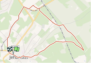
Tour Wandern von 5,3 km verfügbar auf Wallonien, Lüttich, Theux. Diese Tour wird von pierreh01 vorgeschlagen.
Beschreibung
Petite balade ensoleillée au départ de Jehanster.
Nous avons emprunté des routes macadamisées, des sentiers campagnards et forestiers parfois rocailleux sur terrain sec.
Distance mesurée avec Sity Trail qui semble plus proche de la réalité.
Ort
Land:
Belgium
Region :
Wallonien
Abteilung/Provinz :
Lüttich
Kommune :
Theux
Standort:
Unknown
Gehen Sie:(Dec)
Gehen Sie:(UTM)
705317 ; 5604566 (31U) N.
Kommentare
Touren in der Umgebung
![Tour Wandern Jalhay - Solwaster. Natura 2000, des sites qui valent le détour. Lg8 - Photo](https://media.geolcdn.com/t/375/260/ext.jpg?maxdim=2&url=https%3A%2F%2Fservices.sitytrail.com%2FGeolivesWS%2FDownloadMedia.ashx%3FTrailID%3D185776%26Media%3D07ec0791-d24b-4377-8f42-10c75b77cede.jpg)
![Wandern Wandern](https://static1.geolcdn.com/sitytour/trail-icons/101.png)
Solwaster. Natura 2000, des sites qui valent le détour. Lg8
Wandern
Schwierig
(9)
Jalhay,
Wallonien,
Lüttich,
Belgium
![](/images/other/stat-length.png)
6,8 km | 9,1 km-effort
1h 58min
![](https://static1.geolcdn.com/siteimages/upload/files/16400158638029165_repeat_loop_refresh_sync_direction_icon.png)
Ja
![Tour Wandern Verviers - Grand vivier - Cossart - Photo](https://media.geolcdn.com/t/375/260/ext.jpg?maxdim=2&url=https%3A%2F%2Fstatic1.geolcdn.com%2Fsiteimages%2Fupload%2Ffiles%2F1553511878bg_sport_marche.png)
![Wandern Wandern](https://static1.geolcdn.com/sitytour/trail-icons/101.png)
Grand vivier - Cossart
Wandern
Einfach
(5)
Verviers,
Wallonien,
Lüttich,
Belgium
![](/images/other/stat-length.png)
4,7 km | 6,4 km-effort
1h 26min
![](https://static1.geolcdn.com/siteimages/upload/files/16400158638029165_repeat_loop_refresh_sync_direction_icon.png)
Ja
![Tour Wandern Jalhay - 2021-11-16_21h27m43_Cirkwi-Balade_à_Jalhay-Royompré_-_47 - Photo](https://media.geolcdn.com/t/375/260/ext.jpg?maxdim=2&url=https%3A%2F%2Fmedia.geolcdn.com%2Ff%2F94c262e0-20e7-4ae2-8b45-01b4c31da73b.jpg)
![Wandern Wandern](https://static1.geolcdn.com/sitytour/trail-icons/101.png)
2021-11-16_21h27m43_Cirkwi-Balade_à_Jalhay-Royompré_-_47
Wandern
Einfach
(2)
Jalhay,
Wallonien,
Lüttich,
Belgium
![](/images/other/stat-length.png)
11 km | 13,9 km-effort
3h 9min
![](https://static1.geolcdn.com/siteimages/upload/files/16400158638029165_repeat_loop_refresh_sync_direction_icon.png)
Ja
![Tour Wandern Jalhay - 2021-11-16_21h12m11_Cirkwi-Solwaster_Sawe_-_balade_56_B (1) - Photo](https://media.geolcdn.com/t/375/260/ext.jpg?maxdim=2&url=https%3A%2F%2Fmedia.geolcdn.com%2Ff%2F081cadfc-4766-4923-92bf-f568c48bec7d.jpg)
![Wandern Wandern](https://static1.geolcdn.com/sitytour/trail-icons/101.png)
2021-11-16_21h12m11_Cirkwi-Solwaster_Sawe_-_balade_56_B (1)
Wandern
Medium
(3)
Jalhay,
Wallonien,
Lüttich,
Belgium
![](/images/other/stat-length.png)
8,5 km | 11,4 km-effort
2h 36min
![](https://static1.geolcdn.com/siteimages/upload/files/16400158638029165_repeat_loop_refresh_sync_direction_icon.png)
Ja
![Tour Wandern Limburg - 20200606 - Hèvremont 8 Km - Photo](https://media.geolcdn.com/t/375/260/ext.jpg?maxdim=2&url=https%3A%2F%2Fmedia.geolcdn.com%2Ff%2F8311f513-ce09-455a-b0ac-51a7423b07df.jpg)
![Wandern Wandern](https://static1.geolcdn.com/sitytour/trail-icons/101.png)
20200606 - Hèvremont 8 Km
Wandern
Schwierig
(1)
Limburg,
Wallonien,
Lüttich,
Belgium
![](/images/other/stat-length.png)
7,9 km | 10,7 km-effort
1h 34min
![](https://static1.geolcdn.com/siteimages/upload/files/16400158638029165_repeat_loop_refresh_sync_direction_icon.png)
Ja
![Tour Laufen Jalhay - Jalhay-Trail-26km - Photo](https://media.geolcdn.com/t/375/260/ext.jpg?maxdim=2&url=https%3A%2F%2Fmedia.geolcdn.com%2Ff%2Fcfb58ec0-2055-46b2-8eac-aa502bd39e7d.jpg)
![Laufen Laufen](https://static1.geolcdn.com/sitytour/trail-icons/103.png)
Jalhay-Trail-26km
Laufen
Schwierig
(9)
Jalhay,
Wallonien,
Lüttich,
Belgium
![](/images/other/stat-length.png)
26 km | 34 km-effort
3h 0min
![](https://static1.geolcdn.com/siteimages/upload/files/16400158638029165_repeat_loop_refresh_sync_direction_icon.png)
Ja
![Tour Zu Fuß Theux - Chemin des Sources - Einführung in die Wanderung in Polleur - Photo](https://media.geolcdn.com/t/375/260/ext.jpg?maxdim=2&url=https%3A%2F%2Fmedia.geolcdn.com%2Ff%2F7fa33f7a-cba1-4f6e-98fb-216ec34e6071.JPEG)
![Zu Fuß Zu Fuß](https://static1.geolcdn.com/sitytour/trail-icons/100.png)
Chemin des Sources - Einführung in die Wanderung in Polleur
Zu Fuß
Einfach
(1)
Theux,
Wallonien,
Lüttich,
Belgium
![](/images/other/stat-length.png)
7,5 km | 9,9 km-effort
2h 14min
![](https://static1.geolcdn.com/siteimages/upload/files/16400158638029165_repeat_loop_refresh_sync_direction_icon.png)
Ja
![Tour Pfad Jalhay - Extratrail - Jalhay (rouge) 25,8 km - Photo](https://media.geolcdn.com/t/375/260/ext.jpg?maxdim=2&url=https%3A%2F%2Fmedia.geolcdn.com%2Ff%2F0e8266cc-aba5-4632-b62b-dc488e1b972c.jpg)
![Pfad Pfad](https://static1.geolcdn.com/sitytour/trail-icons/104.png)
Extratrail - Jalhay (rouge) 25,8 km
Pfad
Schwierig
(1)
Jalhay,
Wallonien,
Lüttich,
Belgium
![](/images/other/stat-length.png)
26 km | 34 km-effort
Unbekannt
![](https://static1.geolcdn.com/siteimages/upload/files/16400158638029165_repeat_loop_refresh_sync_direction_icon.png)
Ja
![Tour Wandern Verviers - Stembert . les Roudoudous . Stembert - Photo](https://media.geolcdn.com/t/375/260/ext.jpg?maxdim=2&url=https%3A%2F%2Fmedia.geolcdn.com%2Ff%2F83013b57-22fc-4f55-b86f-1cd16e0258d4.jpg)
![Wandern Wandern](https://static1.geolcdn.com/sitytour/trail-icons/101.png)
Stembert . les Roudoudous . Stembert
Wandern
Einfach
(2)
Verviers,
Wallonien,
Lüttich,
Belgium
![](/images/other/stat-length.png)
10,5 km | 13,5 km-effort
2h 48min
![](https://static1.geolcdn.com/siteimages/upload/files/16400158638029165_repeat_loop_refresh_sync_direction_icon.png)
Ja