


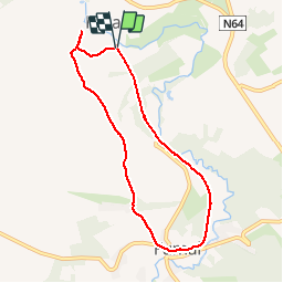


21 km | 26 km-effort

Benutzer


Kostenlosegpshiking-Anwendung
 SityTrail
IGN / Geografische Institute
SityTrail World
Die Welt öffnet sich für Sie
Tour Wandern von 6,7 km verfügbar auf Wallonien, Lüttich, Braives. Diese Tour wird von nicolibris vorgeschlagen.
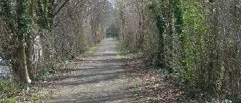
Promenade facile. La première partie emprunte le Ravel qui longe la Mehaigne ; la seconde partie, un chemin de terre sur les hauteurs de la vallée.


Wandern

Wandern
Wandern
Wandern
Wandern
Wandern
Wandern
Wandern
Très belle promenade