Villar-Loubière, Hautes-Alpes: Best trails, routes and walks

Villar-Loubière: Discover the best trails: 36 hiking trails and 1 bike and mountain-bike routes. All these trails, routes and outdoor activities are available in our SityTrail applications for smartphones and tablets.


The best trails (37)

Trail Walking Villar-Loubière - Valgo2 - J1 : Col des Clochettes - Photo
Walking 14.635
Km

Walking

Difficult
Villar-Loubière, Provence-Alpes-Côte d'Azur, Hautes-Alpes, France
14.6 km | 30 km-effort
4h 12min
1146 m
1163 m
Yes
ETMU5496

Trail Walking Villar-Loubière - Cime de Turbat.  - Photo
Walking 15.103
Km

Walking

Difficult
Villar-Loubière, Provence-Alpes-Côte d'Azur, Hautes-Alpes, France
15.1 km | 32 km-effort
7h 31min
1050 m
1962 m
No
Dervalmarc

Trail Walking Villar-Loubière - Refuge des souffles.  - Photo
Walking 4.495
Km

Walking

Medium
Villar-Loubière, Provence-Alpes-Côte d'Azur, Hautes-Alpes, France
4.5 km | 13.7 km-effort
2h 1min
922 m
9 m
No
Dervalmarc

Trail Walking Villar-Loubière - J2 Valgo - Photo
Walking 15.253
Km

Walking

Difficult
Villar-Loubière, Provence-Alpes-Côte d'Azur, Hautes-Alpes, France
15.3 km | 30 km-effort
Unknown
908 m
1768 m
No
ETMU5496

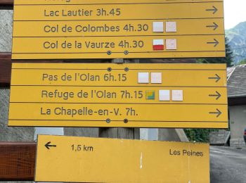
• Séjour REV juin 2019 2eme jour Le refuge des souffles col des cochettes le Lautier col de colombes Pas de l'Olan refu...

Trail Mountain bike Villar-Loubière - vtt 6 valgaudemar - Photo
Mountain bike 20.257
Km

Mountain bike

Difficult
Villar-Loubière, Provence-Alpes-Côte d'Azur, Hautes-Alpes, France
20 km | 27 km-effort
2h 42min
523 m
524 m
Yes
dadodeca

• ludique physique technique

Trail Walking Villar-Loubière - ECRIN Etape 8 Refuge des souffles- Le désert Valjouffrey - Photo
Walking 11.731
Km

Walking

Difficult
Villar-Loubière, Provence-Alpes-Côte d'Azur, Hautes-Alpes, France
11.7 km | 23 km-effort
6h 45min
669 m
1353 m
No
yves12

Trail Walking Villar-Loubière - Tour de l'Oisans - Refuge des Souffles (1975 m) à Valsenestre (1492  m)   - Photo
Walking 16.815
Km

Walking

Difficult
Villar-Loubière, Provence-Alpes-Côte d'Azur, Hautes-Alpes, France
16.8 km | 41 km-effort
7h 30min
1678 m
2123 m
No
tracegps

Trail Walking Villar-Loubière - Tour des Écrins J6 - Photo
Walking 28.415
Km

Walking

Very difficult
Villar-Loubière, Provence-Alpes-Côte d'Azur, Hautes-Alpes, France
28 km | 65 km-effort
10h 0min
2802 m
2642 m
No
ploopakete

Trail Walking Villar-Loubière - J1 Valgo Cabane du Lautier Col des Cochettes Les Souffles IBP 134 - Photo
Walking 12.232
Km

Walking

Difficult
Villar-Loubière, Provence-Alpes-Côte d'Azur, Hautes-Alpes, France
12.2 km | 27 km-effort
6h 12min
1131 m
1128 m
Yes
jouans

Trail Walking Villar-Loubière - Valgaudemar J2 pour les courageux - Photo
Walking 5.878
Km

Walking

Medium
Villar-Loubière, Provence-Alpes-Côte d'Azur, Hautes-Alpes, France
5.9 km | 7.2 km-effort
1h 30min
77 m
167 m
No
jouans

Trail Walking Villar-Loubière - vilard / lac lautier - Photo
Walking 9.873
Km

Walking

Medium
Villar-Loubière, Provence-Alpes-Côte d'Azur, Hautes-Alpes, France
9.9 km | 24 km-effort
5h 16min
1411 m
80 m
No
mthomas30

Trail Walking Villar-Loubière - les souffles - Photo
Walking 8.129
Km

Walking

Medium
Villar-Loubière, Provence-Alpes-Côte d'Azur, Hautes-Alpes, France
8.1 km | 15.4 km-effort
2h 54min
544 m
539 m
Yes
vicant

Trail Walking Villar-Loubière - Tour des Ecrins - J1 - Photo
Walking 16.554
Km

Walking

Difficult
Villar-Loubière, Provence-Alpes-Côte d'Azur, Hautes-Alpes, France
16.6 km | 37 km-effort
6h 46min
1625 m
1350 m
No
GAPIAN43

Trail Walking Villar-Loubière - Refuge des soufles.13 04 14 - Photo
Walking 16.061
Km

Walking

Medium
Villar-Loubière, Provence-Alpes-Côte d'Azur, Hautes-Alpes, France
16.1 km | 35 km-effort
6h 50min
1396 m
1393 m
Yes
Dervalmarc

Trail Walking Villar-Loubière - Ref des Souffles- Désert en Valjouffrey - Photo
Walking 9.628
Km

Walking

Difficult
Villar-Loubière, Provence-Alpes-Côte d'Azur, Hautes-Alpes, France
9.6 km | 21 km-effort
3h 53min
664 m
1352 m
No
edouard_bieber

Trail Nordic walking Villar-Loubière - Ecrins8 - Bis -  Le Désert en Valjourffrey - Photo
Nordic walking 9.299
Km

Nordic walking

Medium
Villar-Loubière, Provence-Alpes-Côte d'Azur, Hautes-Alpes, France
9.3 km | 20 km-effort
3h 44min
647 m
1338 m
No
zemarge

Trail Nordic walking Villar-Loubière - Ecrins9 - Le désert Valjouffrey - V0 - Photo
Nordic walking 13.48
Km

Nordic walking

Medium
Villar-Loubière, Provence-Alpes-Côte d'Azur, Hautes-Alpes, France
13.5 km | 33 km-effort
6h 42min
1524 m
1324 m
No
zemarge

Trail Walking Villar-Loubière - Villar-Loubière / Souffles / La Chapelle en Valgaudemar - Photo
Walking 19.986
Km

Walking

Medium
Villar-Loubière, Provence-Alpes-Côte d'Azur, Hautes-Alpes, France
20 km | 39 km-effort
7h 49min
1408 m
1414 m
Yes
gilbinrod

Trail Walking Villar-Loubière - Etape6 - Refuge des Souffles - Photo
Walking 10.629
Km

Walking

Very easy
Villar-Loubière, Provence-Alpes-Côte d'Azur, Hautes-Alpes, France
10.6 km | 22 km-effort
Unknown
653 m
1328 m
No
fonsdel

Trail Walking Villar-Loubière - YHH079 Refuges des Souffles - Photo
Walking 10.843
Km

Walking

Very easy
Villar-Loubière, Provence-Alpes-Côte d'Azur, Hautes-Alpes, France
10.8 km | 24 km-effort
5h 40min
957 m
955 m
Yes
yveshumbert

20 trails displayed on 37

FREE GPS app for hiking

Logo SityTrail SityTrail

IGN / Geographical institutes

Download SityTrail from the App Store Download SityTrail from Google Play

Logo SityTrail SityTrail World

The world is yours!

Download SityTrail from the App Store Download SityTrail from Google Play Download SityTrail on Huawei AppGallery

Activities

Close
My subscriptions