Laconia Regional Unit, Peloponnese, Western Greece and the Ionian: Best trails, routes and walks

Laconia Regional Unit: Discover the best trails: 3 hiking trails. All these trails, routes and outdoor activities are available in our SityTrail applications for smartphones and tablets.


The best trails (3)

Trail Walking  - Monenvasia  - Photo
Walking 4.275
Km

Walking

Difficult
, Peloponnese, Western Greece and the Ionian, Laconia Regional Unit, Greece
4.3 km | 6.4 km-effort
1h 31min
150 m
182 m
No
Lobin

Trail On foot  - Hiking around Monemvasia (Route P2) - Photo
On foot 7.652
Km
PRO

On foot

Easy
, Peloponnese, Western Greece and the Ionian, Laconia Regional Unit, Greece
7.7 km | 12.5 km-effort
2h 50min
400 m
255 m
No
SityTrail - itinéraires balisés pédestres

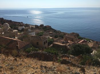
• Trail created by Cultural Association of Koulendia (2008). Symbol: red dot on rocks

Trail Walking  - château oitylo - Photo
Walking 7.221
Km

Walking

Very easy
, Peloponnese, Western Greece and the Ionian, Laconia Regional Unit, Greece
7.2 km | 10.8 km-effort
2h 18min
270 m
270 m
Yes
theo89

3 trails displayed on 3

FREE GPS app for hiking

Logo SityTrail SityTrail

IGN / Geographical institutes

Download SityTrail from the App Store Download SityTrail from Google Play

Logo SityTrail SityTrail World

The world is yours!

Download SityTrail from the App Store Download SityTrail from Google Play Download SityTrail on Huawei AppGallery

Activities

Close
My subscriptions