Belpasso, Catania: Best trails, routes and walks

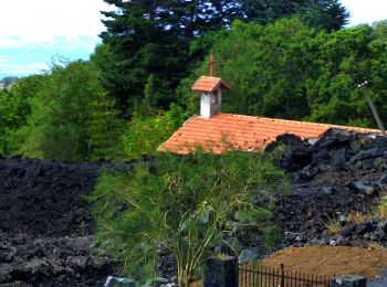
Belpasso: Discover the best trails: 3 hiking trails. All these trails, routes and outdoor activities are available in our SityTrail applications for smartphones and tablets.


The best trails (3)

Trail On foot Belpasso - Pista Altomontana - Photo
On foot 34.125
Km
PRO

On foot

Very difficult
Belpasso, Sicily, Catania, Italy
34 km | 45 km-effort
10h 8min
709 m
1031 m
No
SityTrail - itinéraires balisés pédestres

• Trail created by CAI - Parco dell'Etna. Symbol: 701 on white red flag

Trail On foot Belpasso - Belpasso - Monte Manfrè - Photo
On foot 14.486
Km
PRO

On foot

Medium
Belpasso, Sicily, Catania, Italy
14.5 km | 23 km-effort
5h 14min
851 m
28 m
No
SityTrail - itinéraires balisés pédestres

• Trail created by CAI Belpasso - Parco dell'Etna - Comune di Belpasso. Symbol: 786 on white red flag Website: http:...

Trail On foot Belpasso - Monte Manfrè - Pista Altomontana - Photo
On foot 3.563
Km
PRO

On foot

Easy
Belpasso, Sicily, Catania, Italy
3.6 km | 6.9 km-effort
1h 34min
335 m
6 m
No
SityTrail - itinéraires balisés pédestres

• Trail created by CAI Belpasso - Parco dell'Etna - Comune di Belpasso. Symbol: 786B on white red flag Website: http...

3 trails displayed on 3

FREE GPS app for hiking

Logo SityTrail SityTrail

IGN / Geographical institutes

Download SityTrail from the App Store Download SityTrail from Google Play

Logo SityTrail SityTrail World

The world is yours!

Download SityTrail from the App Store Download SityTrail from Google Play Download SityTrail on Huawei AppGallery

Activities

Close
My subscriptions