


Circuit VTT n 1 départ Chalencon

choubaka77
User
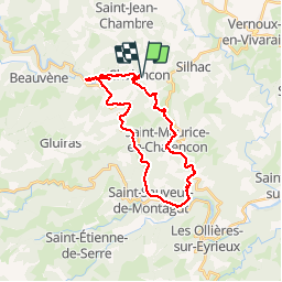


3h10
Difficulty : Difficult

FREE GPS app for hiking
 SityTrail
IGN / Geographical institutes
SityTrail Plus
The world is yours!
About
Trail Mountain bike of 27 km to be discovered at Auvergne-Rhône-Alpes, Ardèche, Chalencon. This trail is proposed by choubaka77.
Description
Circuit difficile avec des passages très techniques ou physiques ou il faut parfois mieux les passer à pieds, ce que j'ai fait. Monter sur Chalencon en fin de parcours très physique avec certains passages à faire à pieds sauf peut être pour les personnes très entraînées. Au demeurant un parcours très sympathique.
Positioning
Comments