


Chalencon Circuit 2

choubaka77
User
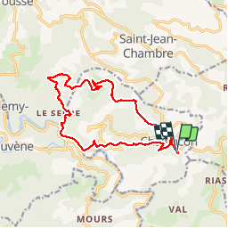


4h28
Difficulty : Medium

FREE GPS app for hiking
 SityTrail
IGN / Geographical institutes
SityTrail Plus
The world is yours!
About
Trail Walking of 15.6 km to be discovered at Auvergne-Rhône-Alpes, Ardèche, Chalencon. This trail is proposed by choubaka77.
Description
Très beau circuit de randonnée avec un petit bémol sur le tracé du GRP qui n'est pas top au niveau de l'entretien. À déconseiller avec de jeunes enfants, ados au minimum et vous risquez de les entendre......
Photos


21 photos in total. Please click on a photo to see them all in the gallery.
Positioning
Comments