


OCC 2018

jybouteyre
User
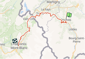

Length
55 km

Max alt
2071 m

Uphill gradient
3445 m
Km-Effort
101 km

Min alt
894 m

Downhill gradient
3297 m
Boucle
No
Creation date :
2019-01-15 12:51:03.377
Updated on :
2019-01-15 12:51:03.377
10h00
Difficulty : Very difficult

FREE GPS app for hiking
 SityTrail
IGN / Geographical institutes
SityTrail Plus
The world is yours!
About
Trail Running of 55 km to be discovered at Valais/Wallis, Entremont, Orsières. This trail is proposed by jybouteyre.
Positioning
Country:
Switzerland
Region :
Valais/Wallis
Department/Province :
Entremont
Municipality :
Orsières
Location:
Unknown
Start:(Dec)
Start:(UTM)
356530 ; 5098852 (32T) N.
Comments