


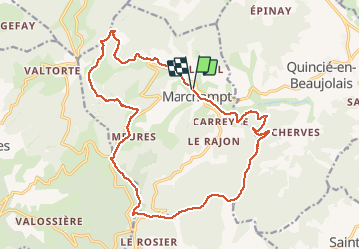
Marchampt 09-07-18

Thomasdanielle
User

Length
21 km

Max alt
789 m

Uphill gradient
753 m
Km-Effort
31 km

Min alt
329 m

Downhill gradient
756 m
Boucle
Yes
Creation date :
2019-01-15 12:54:32.822
Updated on :
2019-01-15 12:54:32.822
6h29
Difficulty : Easy

FREE GPS app for hiking
 SityTrail
IGN / Geographical institutes
SityTrail Plus
The world is yours!
About
Trail Walking of 21 km to be discovered at Auvergne-Rhône-Alpes, Rhône, Marchampt. This trail is proposed by Thomasdanielle.
Description
Marche avec les Galindos et Claudette/Jean
Positioning
Country:
France
Region :
Auvergne-Rhône-Alpes
Department/Province :
Rhône
Municipality :
Marchampt
Location:
Unknown
Start:(Dec)
Start:(UTM)
621310 ; 5107907 (31T) N.
Comments