


Forêt du Pertre

chasle
User
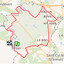

Length
22 km

Max alt
187 m

Uphill gradient
241 m
Km-Effort
25 km

Min alt
114 m

Downhill gradient
242 m
Boucle
Yes
Creation date :
2019-01-15 13:01:12.906
Updated on :
2019-01-15 13:01:12.906
5h27
Difficulty : Easy

FREE GPS app for hiking
 SityTrail
IGN / Geographical institutes
SityTrail Plus
The world is yours!
About
Trail Walking of 22 km to be discovered at Brittany, Ille-et-Vilaine, Argentré-du-Plessis. This trail is proposed by chasle.
Positioning
Country:
France
Region :
Brittany
Department/Province :
Ille-et-Vilaine
Municipality :
Argentré-du-Plessis
Location:
Unknown
Start:(Dec)
Start:(UTM)
642742 ; 5322831 (30U) N.
Comments