


St Claude la savane à mulets

sameja
User
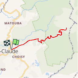

Length
10.6 km

Max alt
1147 m

Uphill gradient
621 m
Km-Effort
18.9 km

Min alt
513 m

Downhill gradient
622 m
Boucle
Yes
Creation date :
2019-01-15 13:05:19.588
Updated on :
2019-01-15 13:05:19.588
1h30
Difficulty : Medium

FREE GPS app for hiking
 SityTrail
IGN / Geographical institutes
SityTrail Plus
The world is yours!
About
Trail Other activity of 10.6 km to be discovered at Guadeloupe, Unknown, Saint-Claude. This trail is proposed by sameja.
Description
Pied de la soufrière
Positioning
Country:
France
Region :
Guadeloupe
Department/Province :
Unknown
Municipality :
Saint-Claude
Location:
Unknown
Start:(Dec)
Start:(UTM)
639496 ; 1772398 (20Q) N.
Comments