


les 3 sommets

sameja
User
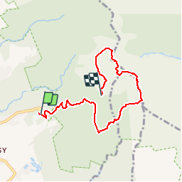

Length
9.3 km

Max alt
1449 m

Uphill gradient
1006 m
Km-Effort
22 km

Min alt
746 m

Downhill gradient
654 m
Boucle
No
Creation date :
2019-01-15 13:05:20.572
Updated on :
2019-01-15 13:05:20.572
3h01
Difficulty : Difficult

FREE GPS app for hiking
 SityTrail
IGN / Geographical institutes
SityTrail Plus
The world is yours!
About
Trail Other activity of 9.3 km to be discovered at Guadeloupe, Unknown, Saint-Claude. This trail is proposed by sameja.
Description
Armistice échelle la soufrière
Photos

Positioning
Country:
France
Region :
Guadeloupe
Department/Province :
Unknown
Municipality :
Saint-Claude
Location:
Unknown
Start:(Dec)
Start:(UTM)
641153 ; 1772834 (20Q) N.
Comments