


2012-02-06 Marche Col de la Golèse

holtzv
User GUIDE
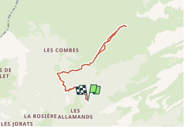

Length
8.7 km

Max alt
1660 m

Uphill gradient
551 m
Km-Effort
16 km

Min alt
1111 m

Downhill gradient
550 m
Boucle
Yes
Creation date :
2014-12-10 00:00:00.0
Updated on :
2014-12-10 00:00:00.0
4h05
Difficulty : Difficult
FREE GPS app for hiking
 SityTrail
IGN / Geographical institutes
SityTrail Plus
The world is yours!
About
Trail Walking of 8.7 km to be discovered at Auvergne-Rhône-Alpes, Upper Savoy, Samoëns. This trail is proposed by holtzv.


Positioning
Country:
France
Region :
Auvergne-Rhône-Alpes
Department/Province :
Upper Savoy
Municipality :
Samoëns
Location:
Unknown
Start:(Dec)
Start:(UTM)
326164 ; 5109000 (32T) N.
Comments