


Clapiers St Etienne d'Issensac

ARVIEU
User
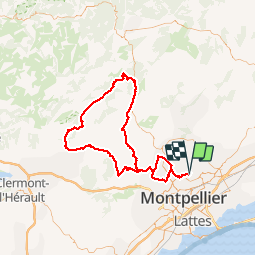

Length
118 km

Max alt
329 m

Uphill gradient
1634 m
Km-Effort
140 km

Min alt
40 m

Downhill gradient
1626 m
Boucle
No
Creation date :
2019-01-15 13:09:39.025
Updated on :
2019-01-15 13:09:39.025
4h40
Difficulty : Medium

FREE GPS app for hiking
 SityTrail
IGN / Geographical institutes
SityTrail Plus
The world is yours!
About
Trail Cycle of 118 km to be discovered at Occitania, Hérault, Clapiers. This trail is proposed by ARVIEU.
Positioning
Country:
France
Region :
Occitania
Department/Province :
Hérault
Municipality :
Clapiers
Location:
Unknown
Start:(Dec)
Start:(UTM)
571947 ; 4834133 (31T) N.
Comments