


sainte croix die_backup

olivieraron
User
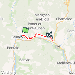

Length
7.5 km

Max alt
403 m

Uphill gradient
103 m
Km-Effort
8.9 km

Min alt
360 m

Downhill gradient
95 m
Boucle
No
Creation date :
2019-01-14 09:42:20.157
Updated on :
2019-01-14 09:42:21.309
50m
Difficulty : Unknown

FREE GPS app for hiking
 SityTrail
IGN / Geographical institutes
SityTrail Plus
The world is yours!
About
Trail Other activity of 7.5 km to be discovered at Auvergne-Rhône-Alpes, Drôme, Sainte-Croix. This trail is proposed by olivieraron.
Positioning
Country:
France
Region :
Auvergne-Rhône-Alpes
Department/Province :
Drôme
Municipality :
Sainte-Croix
Location:
Unknown
Start:(Dec)
Start:(UTM)
680757 ; 4959799 (31T) N.
Comments