Tour du lac de Retournemer et cascade Charlemagne

Baltykatt
User
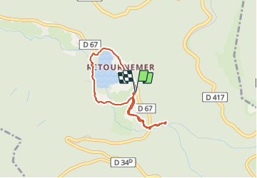

Length
3 km

Max alt
856 m

Uphill gradient
100 m
Km-Effort
4.3 km

Min alt
780 m

Downhill gradient
99 m
Boucle
Yes
Creation date :
2019-01-15 13:18:55.994
Updated on :
2019-01-15 13:18:55.994
1h08
Difficulty : Easy

FREE GPS app for hiking
 SityTrail
IGN / Geographical institutes
SityTrail Plus
The world is yours!
About
Trail Walking of 3 km to be discovered at Grand Est, Vosges, Xonrupt-Longemer. This trail is proposed by Baltykatt.
Positioning
Country:
France
Region :
Grand Est
Department/Province :
Vosges
Municipality :
Xonrupt-Longemer
Location:
Unknown
Start:(Dec)
Start:(UTM)
350028 ; 5324446 (32U) N.
Comments