oronaye roburent

japy54
User GUIDE
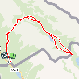

Length
12.2 km

Max alt
2507 m

Uphill gradient
533 m
Km-Effort
19.3 km

Min alt
1992 m

Downhill gradient
534 m
Boucle
Yes
Creation date :
2019-01-15 13:22:42.803
Updated on :
2019-01-15 13:22:42.803
5h05
Difficulty : Medium

FREE GPS app for hiking
 SityTrail
IGN / Geographical institutes
SityTrail Plus
The world is yours!
About
Trail Walking of 12.2 km to be discovered at Provence-Alpes-Côte d'Azur, Alpes-de-Haute-Provence, Val-d'Oronaye. This trail is proposed by japy54.
Positioning
Country:
France
Region :
Provence-Alpes-Côte d'Azur
Department/Province :
Alpes-de-Haute-Provence
Municipality :
Val-d'Oronaye
Location:
Larche
Start:(Dec)
Start:(UTM)
332725 ; 4920905 (32T) N.
Comments