Trail Mountain bike Pélissanne - Ronde des Costes 2006 - Photo
 tracegps
tracegps

User

© OpenStreetMap contributors
Length
Length
29 km
Max alt
Max alt
370 m
Uphill gradient
Uphill gradient
633 m
Km-Effort
Km-Effort  
38 km
Min alt
Min alt
91 m
Downhill gradient
Downhill gradient
633 m
Boucle
Boucle
Yes
Creation date :
2014-12-10 00:00:00.0
Updated on :
2014-12-10 00:00:00.0

(0 Reviews)

Mountain bike
Mountain bike
3h00
Difficulty : Very difficult

Scan this QR Code to open this trail in the SityTrail application

FREE GPS app for hiking

Logo SityTrail SityTrail

IGN / Geographical institutes

Download SityTrail from the App Store Download SityTrail from Google Play

Logo SityTrail SityTrail World

The world is yours!

Download SityTrail from the App Store Download SityTrail from Google Play Download SityTrail on Huawei AppGallery

About

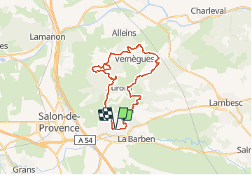
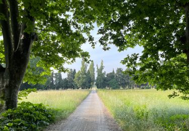
Trail Mountain bike of 29 km to be discovered at Provence-Alpes-Côte d'Azur, Bouches-du-Rhône, Pélissanne. This trail is proposed by tracegps.

Description

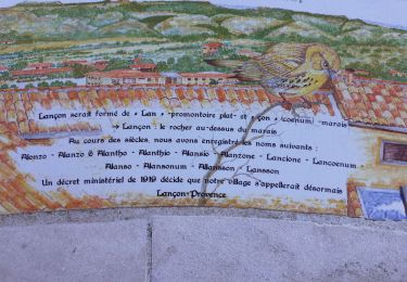
Les Costes c'est le nom de notre région, ils s'étendent sur nos collines entre Pélissanne, Aurons, Vernègues, Alleins, Lamanon et Salon. Une région considérée à juste titre comme l'une des plus belles de notre patrimoine. ( Source )

Elevation profile

Photos

Positioning

Country:
France
Region :
Provence-Alpes-Côte d'Azur
Department/Province :
Bouches-du-Rhône
Municipality :
Pélissanne
Location:
Unknown
Start:(UTM)
673759 ; 4833605 (31T) N.

Trails nearby

Trail Other activity Aurons - cabanon douceur - Photo
Other activity
Claudie090

Other activity

Very easy
(2)
Aurons, Provence-Alpes-Côte d'Azur, Bouches-du-Rhône, France
6.6 km | 8.2 km-effort
3h 4min
Yes
Trail Mountain bike Aurons - Les Deux Bosquets - Photo
Mountain bike
tracegps

Mountain bike

Difficult
(1)
Aurons, Provence-Alpes-Côte d'Azur, Bouches-du-Rhône, France
7.4 km | 9.3 km-effort
2h 0min
Yes
Trail Other activity Aurons - donneiller 2 - Photo
Other activity
Claudie090

Other activity

Very easy
(1)
Aurons, Provence-Alpes-Côte d'Azur, Bouches-du-Rhône, France
10.6 km | 12.6 km-effort
3h 20min
Yes
Trail Walking La Barben - La barben canal - Photo
Walking
Nathy8913

Walking

Very easy
(1)
La Barben, Provence-Alpes-Côte d'Azur, Bouches-du-Rhône, France
11.5 km | 12.7 km-effort
2h 51min
Yes
Trail Mountain bike Aurons - aurons 2010 - Photo
Mountain bike
hollier-larousse

Mountain bike

Very easy
(1)
Aurons, Provence-Alpes-Côte d'Azur, Bouches-du-Rhône, France
31 km | 41 km-effort
Unknown
Yes
Trail Walking La Barben - Entre Touloubre et canal de  Marseille - Photo
Walking
Abigail

Walking

Medium
La Barben, Provence-Alpes-Côte d'Azur, Bouches-du-Rhône, France
15.2 km | 18 km-effort
4h 9min
Yes
Trail Walking Lançon-Provence - Autour de LFMY - Photo
Walking
didierc13

Walking

Medium
Lançon-Provence, Provence-Alpes-Côte d'Azur, Bouches-du-Rhône, France
5.9 km | 6.5 km-effort
1h 37min
Yes
Trail Walking Lançon-Provence - Lancon de Provence chapelle St Symphorien - Photo
Walking
Manoune

Walking

Medium
Lançon-Provence, Provence-Alpes-Côte d'Azur, Bouches-du-Rhône, France
18.7 km | 22 km-effort
6h 1min
Yes
Trail Walking La Barben - La Barben- Vallon de l'Aphoticaire - Photo
Walking
Berpav

Walking

Medium
(1)
La Barben, Provence-Alpes-Côte d'Azur, Bouches-du-Rhône, France
9.6 km | 10.9 km-effort
2h 27min
Yes


Close
My subscriptions