


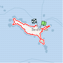
Randonnée. Tour de l'île de Houât.

Dervalmarc
User

Length
14.2 km

Max alt
26 m

Uphill gradient
149 m
Km-Effort
16.3 km

Min alt
0 m

Downhill gradient
160 m
Boucle
No
Creation date :
2019-01-15 13:31:31.799
Updated on :
2019-01-15 13:31:31.799
3h49
Difficulty : Easy

FREE GPS app for hiking
 SityTrail
IGN / Geographical institutes
SityTrail Plus
The world is yours!
About
Trail Walking of 14.2 km to be discovered at Brittany, Morbihan, Île-d'Houat. This trail is proposed by Dervalmarc.
Description
Longue randonnée à faire à la journée pour apprécié tout les charmes de l'île.
Photos


Positioning
Country:
France
Region :
Brittany
Department/Province :
Morbihan
Municipality :
Île-d'Houat
Location:
Unknown
Start:(Dec)
Start:(UTM)
503428 ; 5248549 (30T) N.
Comments