


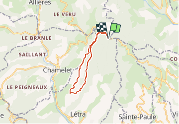
Col du Joncin (DB 25-07-18)

Thomasdanielle
User

Length
10.1 km

Max alt
701 m

Uphill gradient
441 m
Km-Effort
15.9 km

Min alt
361 m

Downhill gradient
441 m
Boucle
Yes
Creation date :
2019-01-15 13:33:21.596
Updated on :
2019-01-15 13:33:21.596
3h17
Difficulty : Unknown

FREE GPS app for hiking
 SityTrail
IGN / Geographical institutes
SityTrail Plus
The world is yours!
About
Trail Walking of 10.1 km to be discovered at Auvergne-Rhône-Alpes, Rhône, Létra. This trail is proposed by Thomasdanielle.
Description
D/A : Col du Joncin (Danièle Baily le 26/07/18 avec Jassans)
Positioning
Country:
France
Region :
Auvergne-Rhône-Alpes
Department/Province :
Rhône
Municipality :
Létra
Location:
Unknown
Start:(Dec)
Start:(UTM)
619675 ; 5095040 (31T) N.
Comments