


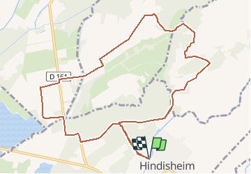
Circuit du Sentier de la Chapelle

tracegps
User


45m
Difficulty : Medium

FREE GPS app for hiking
 SityTrail
IGN / Geographical institutes
SityTrail Plus
The world is yours!
About
Trail Mountain bike of 11.7 km to be discovered at Grand Est, Bas-Rhin, Hindisheim. This trail is proposed by tracegps.
Description
Pour ce circuit-ci ,nous allons relier Hindisheim à la Chapelle de Hattisheim, située près de Geispolsheim et revenir par la forêt entre Blaesheim et l'ancien lavoir, point de départ. Aucune difficulté particulière n'est à signaler. D'autres infos ICI
Photos

Positioning
Comments