Trail Walking Authon - Le cirque des Monges par la crête - Photo
 tracegps
tracegps

User

© OpenStreetMap contributors
Length
Length
12.9 km
Max alt
Max alt
2108 m
Uphill gradient
Uphill gradient
918 m
Km-Effort
Km-Effort  
25 km
Min alt
Min alt
1227 m
Downhill gradient
Downhill gradient
913 m
Boucle
Boucle
Yes
Creation date :
2014-12-10 00:00:00.0
Updated on :
2014-12-10 00:00:00.0

(1 Reviews)

Walking
Walking
5h00
Difficulty : Difficult

Scan this QR Code to open this trail in the SityTrail application

FREE GPS app for hiking

Logo SityTrail SityTrail

IGN / Geographical institutes

Download SityTrail from the App Store Download SityTrail from Google Play

Logo SityTrail SityTrail World

The world is yours!

Download SityTrail from the App Store Download SityTrail from Google Play Download SityTrail on Huawei AppGallery

About

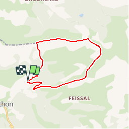
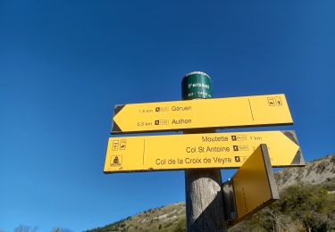
Trail Walking of 12.9 km to be discovered at Provence-Alpes-Côte d'Azur, Alpes-de-Haute-Provence, Authon. This trail is proposed by tracegps.

Description

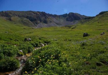
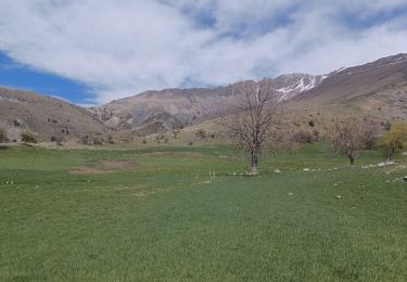
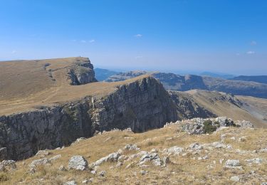
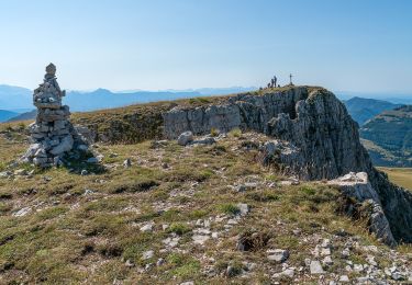
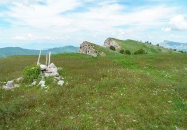
Un cirque majestueux, dépaysant et sauvage. Panorama garanti (lorsque le mistral a bien fait le ménage !) Les Monges sont un des reliefs qui fait la fierté de ce coin des Alpes de Haute Provence. Chaque année, une fête leur est personnellement consacrée. C’est l’occasion, chaque été, pour les marcheurs, au départ des villages limitrophes, de converger vers le sommet de ce cirque majestueux, pour partager à midi un bon repas et festoyer la soirée..... La suite est sur Montagne Cool avec plein de conseils, de photos et d'explications !

Elevation profile

Photos

Positioning

Country:
France
Region :
Provence-Alpes-Côte d'Azur
Department/Province :
Alpes-de-Haute-Provence
Municipality :
Authon
Location:
Unknown
Start:(UTM)
272022 ; 4903542 (32T) N.

Comments

Please log in to post a review or rate the element


Trails nearby

Trail Walking Authon - 20180912_Monges_Authon_Boucle_Sommet Coste belle - Photo
Walking
PapouBertrand

Walking

Difficult
(1)
Authon, Provence-Alpes-Côte d'Azur, Alpes-de-Haute-Provence, France
15.2 km | 28 km-effort
5h 35min
Yes
Trail Walking Bayons - Le sommet des Monges - Bayons - Photo
Walking
tracegps

Walking

Very difficult
(1)
Bayons, Provence-Alpes-Côte d'Azur, Alpes-de-Haute-Provence, France
13.3 km | 22 km-effort
5h 0min
Yes
Trail Walking Authon - AUTHON  Faissal La Croix de Vey ré Sommet de Chine o - Photo
Walking
RobinMicheline

Walking

Difficult
(1)
Authon, Provence-Alpes-Côte d'Azur, Alpes-de-Haute-Provence, France
6.6 km | 13.8 km-effort
4h 50min
Yes
Trail Walking Authon - AUTHON . FAISSAL .LES MONGES . LA CROIX DE VEYRE O L M  - Photo
Walking
RobinMicheline

Walking

Very difficult
Authon, Provence-Alpes-Côte d'Azur, Alpes-de-Haute-Provence, France
14.3 km | 25 km-effort
4h 47min
Yes
Trail Walking Authon - AUTHON . COL DE LA SAPIE .CRETE DU CLOT DES MARTHES . CABAN DE CHINE N - Photo
Walking
RobinMicheline

Walking

Difficult
Authon, Provence-Alpes-Côte d'Azur, Alpes-de-Haute-Provence, France
13.6 km | 22 km-effort
4h 15min
Yes
Trail On foot Authon - SityTrail - Les Monges au départ de Authon - Photo
On foot
Marco05

On foot

Difficult
Authon, Provence-Alpes-Côte d'Azur, Alpes-de-Haute-Provence, France
14.2 km | 27 km-effort
6h 2min
Yes
Trail Walking Authon - Sommet des Monges - Photo
Walking
jalien04

Walking

Difficult
Authon, Provence-Alpes-Côte d'Azur, Alpes-de-Haute-Provence, France
14.7 km | 27 km-effort
7h 26min
Yes
Trail Walking Le Castellard-Mélan - Grotte de st Vincent et Grande Aiguille au départ-arrivée le col de Fontbelle - Photo
Walking
jalien04

Walking

Medium
Le Castellard-Mélan, Provence-Alpes-Côte d'Azur, Alpes-de-Haute-Provence, France
10.4 km | 17.8 km-effort
4h 0min
Yes
Trail Walking Le Castellard-Mélan - Geruen au départ du col de Fontbelle  - Photo
Walking
jalien04

Walking

Easy
Le Castellard-Mélan, Provence-Alpes-Côte d'Azur, Alpes-de-Haute-Provence, France
15.1 km | 25 km-effort
6h 51min
Yes


Close
My subscriptions