


lac bleu

chasle
User
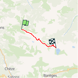

Length
9.2 km

Max alt
2297 m

Uphill gradient
915 m
Km-Effort
20 km

Min alt
1598 m

Downhill gradient
507 m
Boucle
No
Creation date :
2019-01-15 13:51:54.871
Updated on :
2019-01-15 13:51:54.871
--
Difficulty : Unknown

FREE GPS app for hiking
 SityTrail
IGN / Geographical institutes
SityTrail Plus
The world is yours!
About
Trail Walking of 9.2 km to be discovered at Occitania, Hautespyrenees, Beaucens. This trail is proposed by chasle.
Description
par Hautacam
Positioning
Country:
France
Region :
Occitania
Department/Province :
Hautespyrenees
Municipality :
Beaucens
Location:
Unknown
Start:(Dec)
Start:(UTM)
744455 ; 4761976 (30T) N.
Comments