


Refuge packe

chasle
User
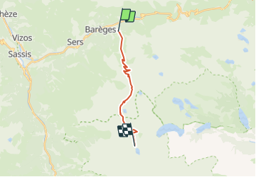

Length
13.1 km

Max alt
2598 m

Uphill gradient
1452 m
Km-Effort
29 km

Min alt
1519 m

Downhill gradient
383 m
Boucle
No
Creation date :
2019-01-15 13:51:57.054
Updated on :
2019-01-15 13:51:57.054
56m
Difficulty : Unknown

FREE GPS app for hiking
 SityTrail
IGN / Geographical institutes
SityTrail Plus
The world is yours!
About
Trail Other activity of 13.1 km to be discovered at Occitania, Hautespyrenees, Barèges. This trail is proposed by chasle.
Positioning
Country:
France
Region :
Occitania
Department/Province :
Hautespyrenees
Municipality :
Barèges
Location:
Unknown
Start:(Dec)
Start:(UTM)
261534 ; 4753215 (31T) N.
Comments