


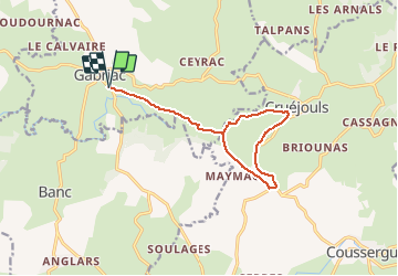
Gabriac/Cruejouls VTT

Strabidja
User

Length
13 km

Max alt
654 m

Uphill gradient
246 m
Km-Effort
16.3 km

Min alt
542 m

Downhill gradient
245 m
Boucle
Yes
Creation date :
2019-04-02 06:02:22.488
Updated on :
2019-04-02 06:02:22.488
1h30
Difficulty : Easy

FREE GPS app for hiking
 SityTrail
IGN / Geographical institutes
SityTrail Plus
The world is yours!
About
Trail Mountain bike of 13 km to be discovered at Occitania, Aveyron, Gabriac. This trail is proposed by Strabidja.
Description
TEST -1ère création d'un parcours entre Gabriac et Cruéjouls.
Positioning
Country:
France
Region :
Occitania
Department/Province :
Aveyron
Municipality :
Gabriac
Location:
Unknown
Start:(Dec)
Start:(UTM)
483820 ; 4921809 (31T) N.
Comments