Trail Walking Couflens - Port de Salau - Photo
 tracegps
tracegps

User

© OpenStreetMap contributors
Length
Length
9.1 km
Max alt
Max alt
2093 m
Uphill gradient
Uphill gradient
1124 m
Km-Effort
Km-Effort  
20 km
Min alt
Min alt
977 m
Downhill gradient
Downhill gradient
19 m
Boucle
Boucle
No
Creation date :
2014-12-10 00:00:00.0
Updated on :
2014-12-10 00:00:00.0

(0 Reviews)

Walking
Walking
3h30
Difficulty : Difficult

Scan this QR Code to open this trail in the SityTrail application

FREE GPS app for hiking

Logo SityTrail SityTrail

IGN / Geographical institutes

Download SityTrail from the App Store Download SityTrail from Google Play

Logo SityTrail SityTrail World

The world is yours!

Download SityTrail from the App Store Download SityTrail from Google Play Download SityTrail on Huawei AppGallery

About

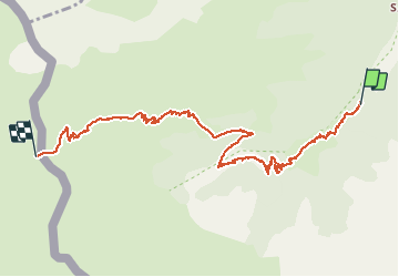
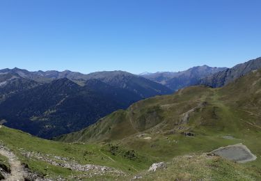
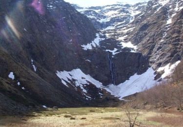
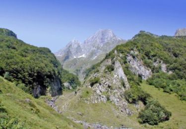
Trail Walking of 9.1 km to be discovered at Occitania, Ariège, Couflens. This trail is proposed by tracegps.

Description

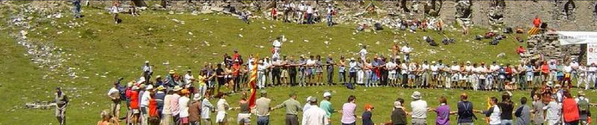
Chaque année, le premier dimanche du mois d'août ont lieu Les Pujadas au Port de Salau : La concrétisation de relations occitano-catalanes ancestrales. ( à voir ICI) Randonnée sur un chemin sans difficulté à part le dénivelé (1100 m) C’est le port le plus bas et le plus accessible de toutes les Pyrénées; il est un lieu de passage depuis des siècles : bergers, contrebandiers, pèlerins de St Jacques de Compostelle, ouvriers allant vendre leur travail du côté espagnol….. Certaines années ils furent 35000 à transiter par le Port de Salau. Il faut compter 3 h et demi pour cette très belle randonnée aller à partir de la route goudronnée, donc 7 heures aller-retour.

Elevation profile

Photos

Positioning

Country:
France
Region :
Occitania
Department/Province :
Ariège
Municipality :
Couflens
Location:
Unknown
Start:(UTM)
351099 ; 4734143 (31T) N.

Trails nearby

Trail Walking Couflens - Cascade de Léziou - Photo
Walking
tracegps

Walking

Medium
(1)
Couflens, Occitania, Ariège, France
4.1 km | 6.3 km-effort
1h 45min
Yes
Trail Mountain bike Couflens - Le Port d' Aula - Photo
Mountain bike
tracegps

Mountain bike

Very difficult
(1)
Couflens, Occitania, Ariège, France
18 km | 37 km-effort
5h 0min
No
Trail Walking Couflens - Cirque d''Anglade - Ariège - Photo
Walking
sebcho

Walking

Very easy
Couflens, Occitania, Ariège, France
4.7 km | 11.3 km-effort
Unknown
No
Trail Walking Couflens - Cirque d''Anglade - Ariège - Photo
Walking
sebcho

Walking

Very easy
Couflens, Occitania, Ariège, France
4.7 km | 11.3 km-effort
Unknown
No
Trail On foot Alt Àneu - route du Port de Salau - Photo
On foot
PRO

On foot

Easy
Alt Àneu, Catalonia, Lleida, Spain
8.4 km | 12.2 km-effort
2h 45min
No
Trail Walking Seix - Port d'Aula - Photo
Walking
GuyVachet

Walking

Medium
(1)
Seix, Occitania, Ariège, France
14.4 km | 24 km-effort
6h 42min
Yes
Trail Walking Couflens - La Lanette - Photo
Walking
tracegps

Walking

Medium
Couflens, Occitania, Ariège, France
8.4 km | 15.3 km-effort
3h 0min
Yes
Trail Walking Couflens - Le cirque d'Anglade - Photo
Walking
tracegps

Walking

Difficult
Couflens, Occitania, Ariège, France
8.3 km | 17.6 km-effort
3h 30min
Yes
Trail Walking Seix - Cabane d'Aula - Photo
Walking
tracegps

Walking

Difficult
Seix, Occitania, Ariège, France
9.4 km | 19.7 km-effort
3h 30min
Yes


Close
My subscriptions