Trail Mountain bike Collonges-au-Mont-d'Or - Tour du Mont Cindre et Mont Thoux - Photo
 tracegps
tracegps

User

© OpenStreetMap contributors
Length
Length
25 km
Max alt
Max alt
563 m
Uphill gradient
Uphill gradient
577 m
Km-Effort
Km-Effort  
33 km
Min alt
Min alt
162 m
Downhill gradient
Downhill gradient
577 m
Boucle
Boucle
Yes
Creation date :
2014-12-10 00:00:00.0
Updated on :
2014-12-10 00:00:00.0

(3 Reviews)

Mountain bike
Mountain bike
1h40
Difficulty : Difficult

Scan this QR Code to open this trail in the SityTrail application

FREE GPS app for hiking

Logo SityTrail SityTrail

IGN / Geographical institutes

Download SityTrail from the App Store Download SityTrail from Google Play

Logo SityTrail SityTrail World

The world is yours!

Download SityTrail from the App Store Download SityTrail from Google Play Download SityTrail on Huawei AppGallery

About

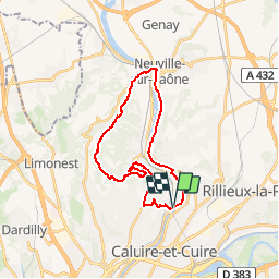
Trail Mountain bike of 25 km to be discovered at Auvergne-Rhône-Alpes, Métropole de Lyon, Collonges-au-Mont-d'Or. This trail is proposed by tracegps.

Description

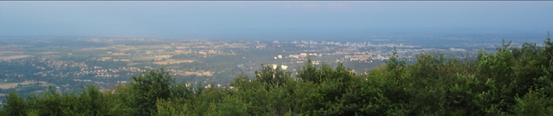
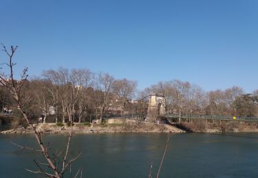
Circuit parfois difficile (portage) sur les chemin du mont Cindre mais dans l'ensemble très agréable, malgrès quelques partie de route, avec pour finir une bonne descente depuis le mont Thoux (beau point de vue sur Lyon et alentours) jusqu'a Albigny sur Saône. Retour au point de départ par les bords de Saône.

Elevation profile

Photos

Positioning

Country:
France
Region :
Auvergne-Rhône-Alpes
Department/Province :
Métropole de Lyon
Municipality :
Collonges-au-Mont-d'Or
Location:
Unknown
Start:(UTM)
643619 ; 5075267 (31T) N.

Comments

Please log in to post a review or rate the element


Trails nearby

Trail Walking Couzon-au-Mont-d'Or - Tour de Couzon par les crêtes - Photo
Walking
boivin101

Walking

Difficult
(2)
Couzon-au-Mont-d'Or, Auvergne-Rhône-Alpes, Métropole de Lyon, France
6.5 km | 10.7 km-effort
2h 5min
Yes
Trail Walking Caluire-et-Cuire - A_CALUIRE 69300 St-Clair - Crépieux - Photo
Walking
ANDREJAC

Walking

Easy
(1)
Caluire-et-Cuire, Auvergne-Rhône-Alpes, Métropole de Lyon, France
10 km | 11.7 km-effort
3h 0min
Yes
Trail Walking Couzon-au-Mont-d'Or - A_COUZON AU MT D'OR 69270  Croix Vitaise - Mont Thoux - Photo
Walking
ANDREJAC

Walking

Medium
(2)
Couzon-au-Mont-d'Or, Auvergne-Rhône-Alpes, Métropole de Lyon, France
8.5 km | 13.6 km-effort
3h 0min
Yes
Trail Mountain bike Lyon - Monts d'Or_02 - Photo
Mountain bike
philmascio

Mountain bike

Medium
(2)
Lyon, Auvergne-Rhône-Alpes, Métropole de Lyon, France
32 km | 45 km-effort
2h 54min
Yes
Trail Mountain bike Fontaines-sur-Saône - Rando de la Madone de Fleurieu sur Saône - Photo
Mountain bike
tracegps

Mountain bike

Medium
(1)
Fontaines-sur-Saône, Auvergne-Rhône-Alpes, Métropole de Lyon, France
24 km | 30 km-effort
2h 30min
Yes
Trail Walking Saint-Cyr-au-Mont-d'Or - s3-c_st_cyr_69450_3d_homme_paysage - Photo
Walking
vidal.galaxy

Walking

Medium
(1)
Saint-Cyr-au-Mont-d'Or, Auvergne-Rhône-Alpes, Métropole de Lyon, France
6.6 km | 9.3 km-effort
2h 6min
Yes
Trail Walking Lyon - cuire et ile barbe - Photo
Walking
maclobar

Walking

Very difficult
Lyon, Auvergne-Rhône-Alpes, Métropole de Lyon, France
17.8 km | 23 km-effort
5h 16min
No
Trail On foot Lyon - Promenade de Rochecardon - Photo
On foot
PRO

On foot

Easy
Lyon, Auvergne-Rhône-Alpes, Métropole de Lyon, France
5.9 km | 8.5 km-effort
1h 55min
No
Trail Walking Saint-Romain-au-Mont-d'Or - Saint-Romain-Au-Mont-D'Or (12 km - D. 490 m) - Photo
Walking
Thomasdanielle

Walking

Difficult
Saint-Romain-au-Mont-d'Or, Auvergne-Rhône-Alpes, Métropole de Lyon, France
11.5 km | 18 km-effort
4h 44min
Yes


Close
My subscriptions