Trail Mountain bike Saint-Alexandre - Alexandrine 2007 (20 km) - Photo

Alexandrine 2007 (20 km)

 tracegps
tracegps

User

© OpenStreetMap contributors
Length
Length
18.7 km
Max alt
Max alt
291 m
Uphill gradient
Uphill gradient
498 m
Km-Effort
Km-Effort  
25 km
Min alt
Min alt
77 m
Downhill gradient
Downhill gradient
502 m
Boucle
Boucle
Yes
Creation date :
2014-12-10 00:00:00.0
Updated on :
2014-12-10 00:00:00.0

(1 Reviews)

Mountain bike
Mountain bike
1h45
Difficulty : Difficult

Scan this QR Code to open this trail in the SityTrail application

FREE GPS app for hiking

Logo SityTrail SityTrail

IGN / Geographical institutes

Download SityTrail from the App Store Download SityTrail from Google Play

Logo SityTrail SityTrail World

The world is yours!

Download SityTrail from the App Store Download SityTrail from Google Play Download SityTrail on Huawei AppGallery

About

Trail Mountain bike of 18.7 km to be discovered at Occitania, Gard, Saint-Alexandre. This trail is proposed by tracegps.

Description

Dans les contre fort des Cévennes, ce parcours très ludique, un peu technique et physique ravira tous les vététistes.

Elevation profile

Positioning

Country:
France
Region :
Occitania
Department/Province :
Gard
Municipality :
Saint-Alexandre
Location:
Unknown
Start:(UTM)
629514 ; 4898535 (31T) N.

Comments

Please log in to post a review or rate the element


Superbe parcours très rythmé avec de nombreux singles. Et heureusement une fin plus calme car les cuisses étaient bien chaudes ! A notre compteur 23 km plutôt que 19 mais encore merci pour la trace !


Trails nearby

Trail Walking Vénéjan - Venejean - Photo
Walking
GUIDE
Roger Philippe Wallez

Walking

Very difficult
Vénéjan, Occitania, Gard, France
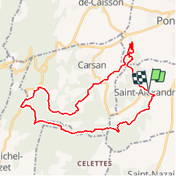
17.5 km | 23 km-effort
6h 26min
Yes
Trail Walking Vénéjan - Vénéjean Chateau de Gicon - Photo
Walking
GUIDE
nadinebondoux

Walking

Medium
Vénéjan, Occitania, Gard, France
16.5 km | 21 km-effort
4h 27min
Yes
Trail Walking Vénéjan - 30 venejean - Photo
Walking
himba26100

Walking

Medium
Vénéjan, Occitania, Gard, France
23 km | 29 km-effort
7h 11min
Yes
Trail Walking Vénéjan - Randonnée Venejean, dent de Marcoule le 29 10 2019 - Photo
Walking
poisson1103

Walking

Medium
Vénéjan, Occitania, Gard, France
20 km | 27 km-effort
7h 28min
Yes
Trail Walking Vénéjan - château de Gicon  - Photo
Walking
Lucien84

Walking

Easy
Vénéjan, Occitania, Gard, France
11.3 km | 15.4 km-effort
4h 3min
Yes
Trail On foot Saint-Paulet-de-Caisson - Valbonne - Photo
On foot
PRO

On foot

Easy
Saint-Paulet-de-Caisson, Occitania, Gard, France
4.1 km | 5.7 km-effort
1h 17min
No
Trail Walking Saint-Paulet-de-Caisson - la valbône par st Paulet - Photo
Walking
Cricounet84

Walking

Easy
Saint-Paulet-de-Caisson, Occitania, Gard, France
17.8 km | 23 km-effort
5h 8min
Yes
Trail Mountain bike Saint-Nazaire - St Nazaire en forêt de Valbonne - Photo
Mountain bike
tracegps

Mountain bike

Difficult
Saint-Nazaire, Occitania, Gard, France
19 km | 25 km-effort
2h 30min
Yes
Trail Walking Vénéjan - De Vénéjan au Château de Gicon - Photo
Walking
tracegps

Walking

Medium
(1)
Vénéjan, Occitania, Gard, France
8 km | 10.6 km-effort
2h 49min
Yes


Close
My subscriptions