


col de l'écuelle

mic-13
User

Length
10.8 km

Max alt
1614 m

Uphill gradient
660 m
Km-Effort
19.6 km

Min alt
1047 m

Downhill gradient
659 m
Boucle
Yes
Creation date :
2019-04-23 15:55:27.253
Updated on :
2019-04-23 15:55:27.394
3h57
Difficulty : Medium

FREE GPS app for hiking
 SityTrail
IGN / Geographical institutes
SityTrail Plus
The world is yours!
About
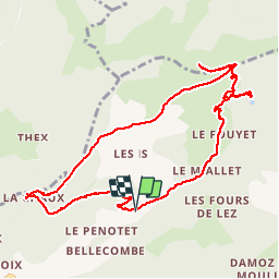
Trail Walking of 10.8 km to be discovered at Auvergne-Rhône-Alpes, Upper Savoy, Saint-Jean-d'Aulps. This trail is proposed by mic-13.
Positioning
Country:
France
Region :
Auvergne-Rhône-Alpes
Department/Province :
Upper Savoy
Municipality :
Saint-Jean-d'Aulps
Location:
Unknown
Start:(Dec)
Start:(UTM)
320240 ; 5124524 (32T) N.
Comments