


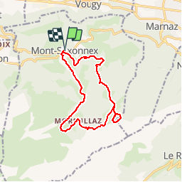
Camp Solaison 2018 - Lac Benit

norbertmarteau
User

Length
13.7 km

Max alt
1569 m

Uphill gradient
731 m
Km-Effort
23 km

Min alt
958 m

Downhill gradient
731 m
Boucle
Yes
Creation date :
2019-01-15 14:05:49.658
Updated on :
2019-01-15 14:05:49.658
4h46
Difficulty : Unknown

FREE GPS app for hiking
 SityTrail
IGN / Geographical institutes
SityTrail Plus
The world is yours!
About
Trail Walking of 13.7 km to be discovered at Auvergne-Rhône-Alpes, Upper Savoy, Mont-Saxonnex. This trail is proposed by norbertmarteau.
Positioning
Country:
France
Region :
Auvergne-Rhône-Alpes
Department/Province :
Upper Savoy
Municipality :
Mont-Saxonnex
Location:
Unknown
Start:(Dec)
Start:(UTM)
305007 ; 5102772 (32T) N.
Comments