


descente de Loire

Orage
User

Length
9.6 km

Max alt
117 m

Uphill gradient
6 m
Km-Effort
9.6 km

Min alt
104 m

Downhill gradient
10 m
Boucle
No
Creation date :
2019-01-15 14:13:06.521
Updated on :
2019-01-15 14:13:06.521
2h01
Difficulty : Easy

FREE GPS app for hiking
 SityTrail
IGN / Geographical institutes
SityTrail Plus
The world is yours!
About
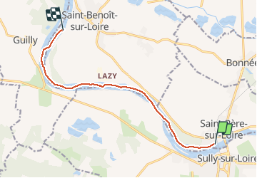
Trail Other activity of 9.6 km to be discovered at Centre-Loire Valley, Loiret, Saint-Père-sur-Loire. This trail is proposed by Orage.
Description
de Saint Père à Saint Benoît
Positioning
Country:
France
Region :
Centre-Loire Valley
Department/Province :
Loiret
Municipality :
Saint-Père-sur-Loire
Location:
Unknown
Start:(Dec)
Start:(UTM)
452615 ; 5290922 (31T) N.
Comments