


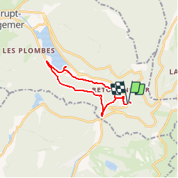
Cascade Charlemagne-Col des Faignes-Rond jaune vers Longemer-Lac Longemer- Lac de Retournemer et retour parking

patrickbeyrath
User

Length
9.6 km

Max alt
1032 m

Uphill gradient
431 m
Km-Effort
15.4 km

Min alt
733 m

Downhill gradient
438 m
Boucle
Yes
Creation date :
2018-10-13 05:51:45.434
Updated on :
2018-10-13 05:51:45.434
3h09
Difficulty : Medium

FREE GPS app for hiking
 SityTrail
IGN / Geographical institutes
SityTrail Plus
The world is yours!
About
Trail Walking of 9.6 km to be discovered at Grand Est, Vosges, Xonrupt-Longemer. This trail is proposed by patrickbeyrath.
Positioning
Country:
France
Region :
Grand Est
Department/Province :
Vosges
Municipality :
Xonrupt-Longemer
Location:
Unknown
Start:(Dec)
Start:(UTM)
350140 ; 5324133 (32U) N.
Comments