


rando autour des vignes de Rotier

jpipacific
User
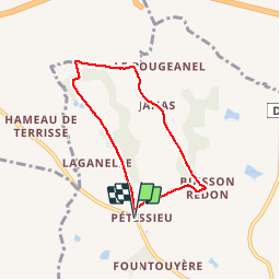

Length
6 km

Max alt
208 m

Uphill gradient
93 m
Km-Effort
7.3 km

Min alt
163 m

Downhill gradient
93 m
Boucle
Yes
Creation date :
2019-01-15 14:36:06.528
Updated on :
2019-01-15 14:36:06.528
1h34
Difficulty : Very easy

FREE GPS app for hiking
 SityTrail
IGN / Geographical institutes
SityTrail Plus
The world is yours!
About
Trail Walking of 6 km to be discovered at Occitania, Tarn, Cadalen. This trail is proposed by jpipacific.
Description
Facile et syma
Positioning
Country:
France
Region :
Occitania
Department/Province :
Tarn
Municipality :
Cadalen
Location:
Unknown
Start:(Dec)
Start:(UTM)
416844 ; 4857191 (31T) N.
Comments